Showing 37–48 of 1050 results
-

A two-sheet map of Europe
£1,000JAILLOT, Alexis-Hubert.
Published In 1705
Stock No. 24059 -

The most important prospect of Brescia
£18,000CARBONI, Domenico.
Published In 1764
Stock No. 23648 -

A detailed map of Victoria in the 1930s
£4,500WAR OFFICE.
Published In 1930
Stock No. 23458 -

An impressive 16th century two-sheet plan of Antwerp
£1,500HOEFNAGEL, Joris.
Published In 1596
Stock No. 23372 -

A large French edition of Lopez’s map of Iberia
£850LOPEZ, Thomas.
Published In 1820
Stock No. 23293 -

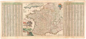
A 17th century map of France with rare gazzetteer side-panels
£750VISSCHER, Nicolas.
Published In 1690
Stock No. 23744 -

Dutch broadsheet of the Anglo-Spanish War, 1727-9
£900LETH, Andries de.
Published In 1727
Stock No. 22698 -

Detailed folding map of the ‘Patriotic War of 1812’
£550VALLARDI, Guiseppe and Pietro.
Published In 1808
Stock No. 22675 -

Detailed folding map of the ‘Patriotic War of 1812’
£960SUKHTELEN & OPPERMAN.
Published In 1808
Stock No. 22673 -

Detailed early 19th century folding map of Russia
£600NANTIAT, Jasper.
Published In 1808
Stock No. 22670 -

16th century map with Cyprus & Crete
£900ORTELIUS, Abraham.
Published In 1573
Stock No. 24407 -

A plan of Geneva with contemporary manuscript for the Revolution of 1782
£2,500GLOT, C.B.
Published In 1777
Stock No. 24391