Showing 1–12 of 69 results
-

Van der Aa’s large format maps of the four Continents in superb colour
£7,500AA, Pieter van der.
Published In 1713
Stock No. 24369 -

Facsimile of Rocque’s 16-Sheet Map of London
£400ROCQUE, John.
Published In 1971
Stock No. 15133 -

Large-format book on antiquarian war maps
£70BAYNTON-WILLIAMS, Ashley & Miles.
Published In 2007
Stock No. 23963 -

Detailed study of British world maps
£45ARMITAGE, Geoff & BAYNTON-WILLIAMS, Ashley.
Published In 2012
Stock No. 20970 -

Facsimile of Ogilby’s ‘Britannia’ road atlas
£60OGILBY, John.
Published In 1939
Stock No. 23868 -

Map of Sumatra and the Malay Peninsula
£425AA, Pieter van der.
Published In 1714
Stock No. 23647 -

The Strait of Malacca & Singapore
£475AA, Pieter van der.
Published In 1714
Stock No. 23646 -

18th century view of the Dutch city of Batavia
£160SALMON, Thomas.
Published In 1753
Stock No. 23642 -

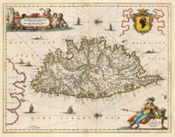
A decorative 17th century map of Corsica
£1,100JANSSON, Jan.
Published In 1650
Stock No. 23619 -

James Boswell’s 18th century tour of Corsica
£680PHINN, Thomas.
Published In 1768
Stock No. 23174 -

A rare Italian map of Corsica
£1,800SOCIETA CALCOGRAFICA.
Published In 1805
Stock No. 23173 -

A 16th century map of Corsica
£260PORCACCHI, Tomaso.
Published In 1590
Stock No. 23212