Showing 1–12 of 125 results
-

Victorian map of China with views of Hong Kong and Canton
£250TALLIS, John.
Published In 1851
Stock No. 23537 -

A serio-comic map of Europe with the Russian octopus
£4,750GROSSI, Augusto.
Published In 1878
Stock No. 24393 -

A pictorial map of Beijing in the 1930s
£3,000DORN, Frank.
Published In 1936
Stock No. 24392 -

A caricature of Churchill as an octopus, produced for occupied France
£1,000S.P.K.
Published In 1942
Stock No. 24106 -

The map of China from the first English atlas of the world
£3,700SPEED, John.
Published In 1665
Stock No. 23978 -

The Salvation Army’s vision of a new Utopia
£250BOOTH, William.
Published In 1890
Stock No. 24450 -

19th century Spanish sea chart of the Yellow Sea and Korea
£2,200BRYANT, Tomas.
Published In 1866
Stock No. 12450 -

A 19th century American sea chart of Hong Kong
£3,500BREWER, H.G.
Published In 1916
Stock No. 23973 -

A detailed map of Victoria in the 1930s
£4,500WAR OFFICE.
Published In 1930
Stock No. 23458 -

A French serio-comic map of Europe for the Great War
£1,850CRETE, B.
Published In 1915
Stock No. 23347 -

An Air France poster map of the world in a double hemisphere
£1,900BOUCHER, Lucien.
Published In 1950
Stock No. 23336 -

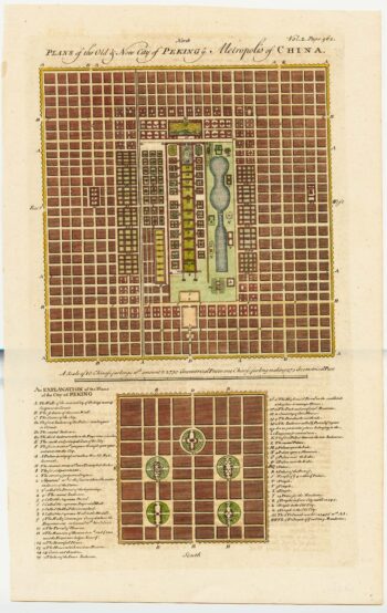
18th century town plan of Peking
£450HARRIS, John.
Published In 1748
Stock No. 23674