Showing 1–12 of 20 results
-

A map of the early Church in Egypt and Lybia
£650SANSON, Nicolas.
Published In 1704
Stock No. 24115 -

A 16th century Italian plan of Cairo
£250VALEGIO, Francesco.
Published In 1598
Stock No. 24146 -

A ‘bird’s-eye’ map of the Gordon Relief Mission, 1884
£1,750BACON, George Washington.
Published In 1885
Stock No. 24107 -

Speed’s maps of the Channel Islands, Farne and Holy Island
£750SPEED, John.
Published In 1627
Stock No. 23822 -

The famous map of Leinster by John Speed
£750SPEED, John.
Published In 1665
Stock No. 23786 -

Map of the Channel Islands of Jersey & Guersney
£125TALLIS, John.
Published In 1851
Stock No. 23517 -

Decorative map of Egypt and the Nile
£450HOMANN, Johann Baptist.
Published In 1725
Stock No. 23263 -

Sea chart of south east Ireland with an inset of Dublin Bay
£550SELLER, Jeremiah.
Published In 1750
Stock No. 23160 -

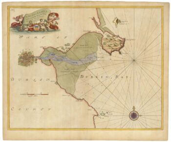
Sea chart of Dublin Bay from the first English sea-atlas
£550COLLINS, Greenvile.
Published In 1693
Stock No. 23156 -

17th century map of Dorset
£600BLAEU, Johannes.
Published In 1662
Stock No. 22703 -

Miniature map of Longford and West Meath
£100PERROT, Aristide Michel.
Published In 1828
Stock No. 23127 -

Miniature map of East Meath
£110PERROT, Aristide Michel.
Published In 1828
Stock No. 23126