Showing 1–12 of 19 results
-

A map of the early Church in Egypt and Lybia
£650SANSON, Nicolas.
Published In 1704
Stock No. 24115 -

A serio-comic map of Europe with the Russian octopus
£4,750GROSSI, Augusto.
Published In 1878
Stock No. 24393 -

A 16th century Italian plan of Cairo
£250VALEGIO, Francesco.
Published In 1598
Stock No. 24146 -

A ‘bird’s-eye’ map of the Gordon Relief Mission, 1884
£1,750BACON, George Washington.
Published In 1885
Stock No. 24107 -

A French serio-comic map of Europe for the Great War
£1,850CRETE, B.
Published In 1915
Stock No. 23347 -

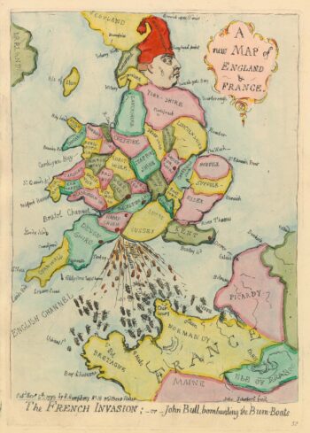
Caricature map of England in danger of invasion, from Gillray’s cruder output
£1,250GILLRAY, James.
Published In 1851
Stock No. 24158 -

Speed’s maps of the Channel Islands, Farne and Holy Island
£750SPEED, John.
Published In 1627
Stock No. 23822 -

Map of the Channel Islands of Jersey & Guersney
£125TALLIS, John.
Published In 1851
Stock No. 23517 -

A rare Italian serio-comic map of Europe in 1871
£20,000MANFREDO, Manfredi.
Published In 1871
Stock No. 23283 -

Decorative map of Egypt and the Nile
£450HOMANN, Johann Baptist.
Published In 1725
Stock No. 23263 -

An Italian edition of Hadol’s serio-comic map of Europe
£1,200HADOL, Paul.
Published In 1888
Stock No. 23202 -

An Italian Serio-Comic map of Europe during the Great War
£2,500Anonymous.
Published In 1915
Stock No. 22636