Showing 1–12 of 76 results
-

The First Edition of Ortelius’s map of the Spice Islands
£4,000ORTELIUS, Abraham.
Published In 1570
Stock No. 24431 -

A map of the early Church in Egypt and Lybia
£650SANSON, Nicolas.
Published In 1704
Stock No. 24115 -

A 16th century Italian plan of Cairo
£250VALEGIO, Francesco.
Published In 1598
Stock No. 24146 -

A ‘bird’s-eye’ map of the Gordon Relief Mission, 1884
£1,750BACON, George Washington.
Published In 1885
Stock No. 24107 -

Speed’s famous map of the Saxon Heptarchy
£2,900SPEED, John.
Published In 1665
Stock No. 23788 -

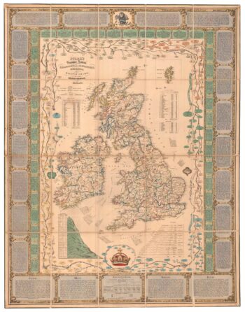
A Victorian educational map of the British Isles
£1,700STARK, J.
Published In 1851
Stock No. 24080 -

A rare map of the British Isles with a prospect of the Great Fire of 1666
£12,000HOLLAR, Wenceslaus.
Published In 1667
Stock No. 24086 -

18th century English map of the East Indies
£440BOWEN, Emanuel.
Published In 1752
Stock No. 21763 -

The route of Saint Ursula and the 11,000 virgin martyrs
£800HOGENBERG, Abraham.
Published In 1647
Stock No. 23910 -

Early 18th century map of the East Indies
£980DELISLE, Guillaume.
Published In 1705
Stock No. 23907 -

Early 18th century map of the British Isles
£220FER, Nicolas de.
Published In 1705
Stock No. 23765 -

A scarce, separate-issue map of the British Isles with decorative borders
£4,000VISSCHER, Claes Janszoon.
Published In 1650
Stock No. 23728