Showing 1–12 of 41 results
-

A monumental sea chart of south-west England
£3,250HOOGHE, Romeyn de.
Published In 1693
Stock No. 24483 -

A rare lifetime printing of Blaeu’s view of Vesuvius erupting in 1631
£1,400BLAEU, Johannes.
Published In 1663
Stock No. 24506 -

A rare 17th century Dutch sea chart of the British Isles
£1,400DONCKER, Hendrik.
Published In 1665
Stock No. 22272 -

An 18th century two-sheet sea chart of the English Channel based on Halley
£1,250MOUNT & PAGE.
Published In 1745
Stock No. 23424 -

18th century illustration of a sundial
£160THOMAS, Corbinianus.
Published In 1730
Stock No. 21490 -

A large and decorative map of Corfu
£750CORONELLI, Vincenzo Maria.
Published In 1690
Stock No. 24095 -

A 17th century illustration of an armillary sphere
£180MALLET, Alain Manesson.
Published In 1683
Stock No. 23928 -
A mid-18th century map of Taiwan
£360BELLIN, Jacques-Nicolas.
Published In 1748
Stock No. 23668 -

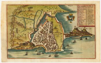
Rare town-plan of Corfu under siege by the Ottomans
£340WIERING, Thomas von.
Published In 1716
Stock No. 23665 -

An 18th century chart of Corfu
£110ROUX, Joseph.
Published In 1804
Stock No. 23636 -

A two-sheet prospect of the Ponte Nuovo, Naples
£3,500RICCIARDELLI, Gabriele.
Published In 1765
Stock No. 23422 -

A two-sheet prospect of Chiaia with the Bay of Naples and Vesuvius
£3,500RICCIARDELLI, Gabriele.
Published In 1765
Stock No. 23421