Showing 1–12 of 85 results
-

A monumental sea chart of south-west England
£3,250HOOGHE, Romeyn de.
Published In 1693
Stock No. 24483 -

A rare 17th century Dutch sea chart of the British Isles
£1,400DONCKER, Hendrik.
Published In 1665
Stock No. 22272 -

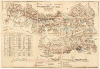
A scarce map of the gold rush near Johannesburg
£1,900TROYE, Gustav Arthur.
Published In 1892
Stock No. 24104 -

An 18th century two-sheet sea chart of the English Channel based on Halley
£1,250MOUNT & PAGE.
Published In 1745
Stock No. 23424 -

Cape of Good Hope naval prospect
£400AA, Pieter van der.
Published In 1719
Stock No. 24077 -

A rare issue of Speed’s famous 17th century map of Hungary
£1,500SPEED, John.
Published In 1665
Stock No. 23990 -

18th century vue d’optique of the Cape of Good Hope
£600RIEDEL, Gottlieb Friedrich.
Published In 1780
Stock No. 23736 -

A 16th century Italian plan of Moscow
£450VALEGIO, Francesco.
Published In 1598
Stock No. 24142 -

Ortelius’s map of Hungary in fine colour
£650ORTELIUS, Abraham.
Published In 1612
Stock No. 23811 -

Ortelius’s map of Hungary in fine original colour
£600ORTELIUS, Abraham.
Published In 1603
Stock No. 23806 -

An unusual 17th century plan of Constantinople
£1,200ISAAC, Jaspar.
Published In 1624
Stock No. 23738 -

A 17th century old map of the Gulf of Guinea in West Africa
£500JANSSON, Jan.
Published In 1680
Stock No. 23630