Showing 1–12 of 24 results
-

A monumental sea chart of south-west England
£3,250HOOGHE, Romeyn de.
Published In 1693
Stock No. 24483 -

A rare 17th century Dutch sea chart of the British Isles
£1,400DONCKER, Hendrik.
Published In 1665
Stock No. 22272 -

A 19th century American sea chart of Hong Kong
£3,500BREWER, H.G.
Published In 1916
Stock No. 23973 -

A detailed map of Victoria in the 1930s
£4,500WAR OFFICE.
Published In 1930
Stock No. 23458 -

An 18th century two-sheet sea chart of the English Channel based on Halley
£1,250MOUNT & PAGE.
Published In 1745
Stock No. 23424 -

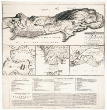
Dutch broadsheet of the Anglo-Spanish War, 1727-9
£900LETH, Andries de.
Published In 1727
Stock No. 22698 -
A mid-18th century map of Taiwan
£360BELLIN, Jacques-Nicolas.
Published In 1748
Stock No. 23668 -
An 18th century sea chart of the English Channel
£450JEFFERYS, Thomas.
Published In 1775
Stock No. 23417 -

The British capture of Gibraltar in 1704
£800DECKER, Paul.
Published In 1720
Stock No. 23319 -

Dutch sea chart of the harbour of Gibraltar
£450KEULEN, Johannes van.
Published In 1630
Stock No. 22708 -

Important map of Taiwan according to the Dutch East India Company
£6,500VALENTYN, François.
Published In 1726
Stock No. 22749 -

Plan of Gibraltar in 1738
£280BASIRE, James.
Published In 1745
Stock No. 22152