Showing 1–12 of 29 results
-

A monumental sea chart of south-west England
£3,250HOOGHE, Romeyn de.
Published In 1693
Stock No. 24483 -

A rare 17th century Dutch sea chart of the British Isles
£1,400DONCKER, Hendrik.
Published In 1665
Stock No. 22272 -

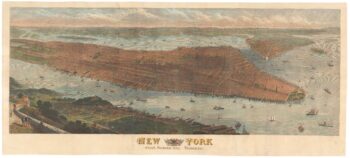
A highly-detailed prospect of Manhattan
£3,500SULMAN, Thomas.
Published In 1876
Stock No. 23720 -

An 18th century two-sheet sea chart of the English Channel based on Halley
£1,250MOUNT & PAGE.
Published In 1745
Stock No. 23424 -

A rare issue of Speed’s famous 17th century map of Hungary
£1,500SPEED, John.
Published In 1665
Stock No. 23990 -

Detailed plan of New York City
£350MITCHELL, Samuel Augustus.
Published In 1860
Stock No. 23834 -

Ortelius’s map of Hungary in fine colour
£650ORTELIUS, Abraham.
Published In 1612
Stock No. 23811 -

Ortelius’s map of Hungary in fine original colour
£600ORTELIUS, Abraham.
Published In 1603
Stock No. 23806 -

A vue-d’optique of the arrival of General Howe in New York City
£400HABERMANN, Franz Xaver.
Published In 1780
Stock No. 23629 -
An 18th century sea chart of the English Channel
£450JEFFERYS, Thomas.
Published In 1775
Stock No. 23417 -

An 17th century map of the Kingdom of Hungary
£450DE WIT, Frederick.
Published In 1688
Stock No. 23292 -

18th century map of New England and New York in original colours
£380BELLIN, Jacques-Nicolas.
Published In 1773
Stock No. 23227