Showing 1–12 of 33 results
-

A 19th century American sea chart of Hong Kong
£3,500BREWER, H.G.
Published In 1916
Stock No. 23973 -

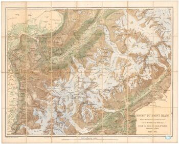
A detailed plan of the Mont-Blanc massif
£1,600BARBEY, Albert.
Published In 1924
Stock No. 22980 -

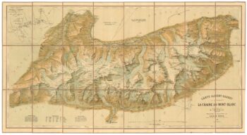
An important map of the Mont Blanc Massif
£950MIEULET, Jean-Joseph.
Published In 1865
Stock No. 24076 -

A detailed map of Victoria in the 1930s
£4,500WAR OFFICE.
Published In 1930
Stock No. 23458 -

The scarce second state of the Lhuyd-Hondius map of Wales
£550LHUYD, Humfrey.
Published In 1638
Stock No. 23841 -

A detailed Victorian map of Burma
£425ARROWSMITH, John.
Published In 1875
Stock No. 23852 -

The first British atlas map of Wales
£1,700SPEED, John.
Published In 1665
Stock No. 23789 -

A scarce 17th century prospect of Saint-Jean-de-Maurienne in superb colour
£400BLAEU, Johannes.
Published In 1682
Stock No. 23269 -

Miniature map of Cardiganshire, Randorshire and Brecknockshire
£75PERROT, Aristide Michel.
Published In 1828
Stock No. 23106 -

Miniature map of Merionethshire and Montgomeryshire
£150PERROT, Aristide Michel.
Published In 1828
Stock No. 23105 -
Miniature map of map of Anglesey
£150PERROT, Aristide Michel.
Published In 1828
Stock No. 23073 -

Blaeu’s map of Pembrokeshire and Carmarthenshire, with fine colour
£500BLAEU, Johannes.
Published In 1662
Stock No. 23042