Showing 1–12 of 56 results
-

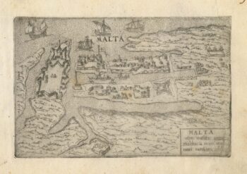
A 16th century town plan of Valletta
£200VALEGIO, Francesco.
Published In 1598
Stock No. 24173 -

The scarce second state of the Lhuyd-Hondius map of Wales
£550LHUYD, Humfrey.
Published In 1638
Stock No. 23841 -

A detailed Victorian map of Burma
£425ARROWSMITH, John.
Published In 1875
Stock No. 23852 -

The first British atlas map of Wales
£1,700SPEED, John.
Published In 1665
Stock No. 23789 -

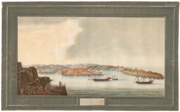
A rare 18th century view of Marsamxett
£3,750PULLICINO, Alberto.
Published In 1770
Stock No. 23426 -

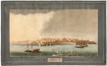
A rare 18th century view of Valletta
£3,750PULLICINO, Alberto.
Published In 1770
Stock No. 23425 -

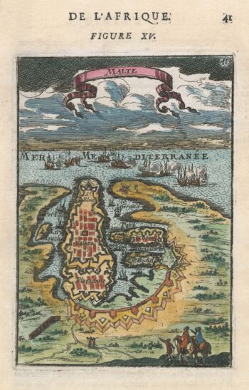
A 17th century miniature plan of Valletta
£220MALLET, Alain Manesson.
Published In 1683
Stock No. 22329 -

Miniature map of Cardiganshire, Randorshire and Brecknockshire
£75PERROT, Aristide Michel.
Published In 1828
Stock No. 23106 -
Miniature map of Merionethshire and Montgomeryshire
£150PERROT, Aristide Michel.
Published In 1828
Stock No. 23105 -
Miniature map of map of Anglesey
£150PERROT, Aristide Michel.
Published In 1828
Stock No. 23073 -

Blaeu’s map of Pembrokeshire and Carmarthenshire, with fine colour
£500BLAEU, Johannes.
Published In 1662
Stock No. 23042 -

A 17th century townplan of Newport
£160HERMANNIDES, Rutger.
Published In 1661
Stock No. 22781