Showing 1–12 of 81 results
-

A 17th century chart of the eastern Mediterranean in fine colour.
£1,600DE WIT, Frederick.
Published In 1745
Stock No. 24490 -

de Hooghe’s spectacular chart of the Mediterranean Sea
£36,500HOOGHE, Romeyn de.
Published In 1694
Stock No. 24488 -

Uncommon 16th century Italian map of Cyprus
£1,600ROSACCIO, Giuseppe.
Published In 1598
Stock No. 24538 -

A rare lifetime printing of Blaeu’s view of Vesuvius erupting in 1631
£1,400BLAEU, Johannes.
Published In 1663
Stock No. 24506 -

Miniature map of Cyprus and the islands of the Aegean
£350HONDIUS, Jodocus II.
Published In 1610
Stock No. 24510 -

16th century map with Cyprus & Crete
£900ORTELIUS, Abraham.
Published In 1573
Stock No. 24407 -

18th century illustration of a sundial
£160THOMAS, Corbinianus.
Published In 1730
Stock No. 21490 -

A 17th century illustration of an armillary sphere
£180MALLET, Alain Manesson.
Published In 1683
Stock No. 23928 -

A scarce edition of Speed’s map of County Durham
£600SPEED, John.
Published In 1665
Stock No. 23820 -

A scarce German edition of Pocock’s map of Cyprus
£650POCOCKE, Richard.
Published In 1745
Stock No. 23804 -

The Peregrinations of Saint Paul in superb original colour
£1,400ORTELIUS, Abraham.
Published In 1603
Stock No. 23745 -

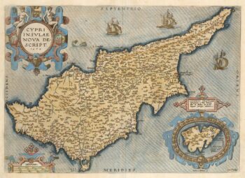
A classic 16th century Dutch map of Cyprus
£1,400ORTELIUS, Abraham.
Published In 1579
Stock No. 23740