Showing 1–12 of 375 results
-

A monumental 18th century wall map of Switzerland on four sheets
£6,500SCHEUCHZER, Johann Jakob.
Published In 1712
Stock No. 24499 -
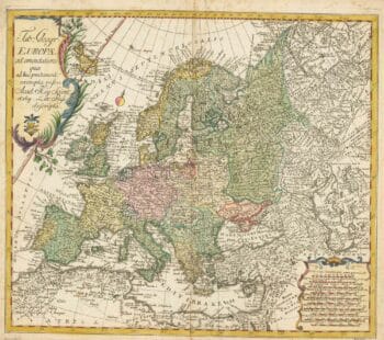
18th century map of Europe
£440EULER, Leonhard.
Published In 1760
Stock No. 24111 -

An early 19th century map of Cornwall
£225CARY, John.
Published In 1805
Stock No. 24114 -

A 16th century map of the colony of New Spain
£750ORTELIUS, Abraham.
Published In 1584
Stock No. 24448 -

A late-18th century plan of Geneva
£250ANDREWS, John.
Published In 1800
Stock No. 24514 -

A late-18th century plan of Berlin
£260ANDREWS, John.
Published In 1800
Stock No. 24513 -

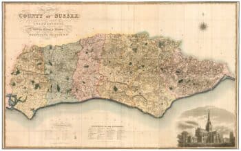
A large scale map of Sussex in fine colour
£2,800GREENWOOD, C. & J.
Published In 1825
Stock No. 24224 -

A large scale map of Nottinghamshire in fine colour
£1,800SANDERSON, George.
Published In 1836
Stock No. 24067 -

An extremely rare example of the first printed plan of Exeter
£4,500HOOKER, John.
Published In 1587
Stock No. 24437 -
First issue of Rumold Mercator’s map of Europe
£2,500MERCATOR, Rumold.
Published In 1595
Stock No. 24298 -

A large scale map of Westmorland in fine colour
£1,500GREENWOOD, C. & J.
Published In 1824
Stock No. 24069 -

A large scale map of Warwickshire in fine colour
£1,600GREENWOOD, C. & J.
Published In 1822
Stock No. 24068