Showing 1–12 of 81 results
-

Russia, from the first English atlas of the World
£2,200SPEED, John.
Published In 1676
Stock No. 23731 -

The founding of St Petersburg by Peter the Great
£700ZATTA, Antonio.
Published In 1797
Stock No. 24504 -

A serio-comic map of Europe with the Russian octopus
£4,750GROSSI, Augusto.
Published In 1878
Stock No. 24393 -

A map of the Russo-Turkish War of 1877-8
£250ILLUSTRATED LONDON NEWS.
Published In 1877
Stock No. 24378 -

The New Zealand gore from Coronelli’s 42 inch globe
£2,200CORONELLI, Vincenzo Maria.
Published In 1693
Stock No. 23716 -

Detailed folding map of the ‘Patriotic War of 1812’
£550VALLARDI, Guiseppe and Pietro.
Published In 1808
Stock No. 22675 -

Detailed folding map of the ‘Patriotic War of 1812’
£960SUKHTELEN & OPPERMAN.
Published In 1808
Stock No. 22673 -

Detailed early 19th century folding map of Russia
£600NANTIAT, Jasper.
Published In 1808
Stock No. 22670 -

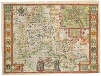
A scarce edition of John Speed’s map of Oxfordshire
£1,600SPEED, John.
Published In 1616
Stock No. 24019 -

A detailed sea chart of the environs of Waitangi in New Zealand
£1,250DUPERREY, Louis-Isidore.
Published In 1829
Stock No. 23961 -

A detailed sea chart of the environs of Manawaora in New Zealand
£1,200DUPERREY, Louis-Isidore.
Published In 1829
Stock No. 23959 -

A French serio-comic map of Europe for the Great War
£1,850CRETE, B.
Published In 1915
Stock No. 23347