Showing 1–12 of 42 results
-

A 16th century woodcut map of Poland, Lithuania and Hungary
£700MUNSTER, Sebastian.
Published In 1572
Stock No. 24574 -

A scarce 18th century map of the Polish-Lithuanian Commonwealth
£950NOLIN, Jean Baptiste jnr.
Published In 1742
Stock No. 24544 -

A 17th century map of Poland
£750DE ROSSI, Giovanni Giacomo.
Published In 1685
Stock No. 24518 -

Four scarce Italian playing cards depicting Poland
£850Anonymous.
Published In 1790
Stock No. 24241 -

16th century woodblock map of Silesia
£300MUNSTER, Sebastian.
Published In 1572
Stock No. 24582 -

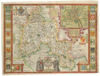
A scarce edition of John Speed’s map of Oxfordshire
£1,600SPEED, John.
Published In 1616
Stock No. 24019 -

Map of the city and university of Oxford
£240MOULE, Thomas.
Published In 1848
Stock No. 23657 -

A map of Oxford in Elizabethan times
£1,250AGAS, Ralph.
Published In 1733
Stock No. 23589 -

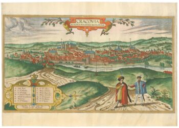
A 16th century prospect of Krakow from the ‘Civitates Orbis Terrarum’
£2,400BRAUN, Georg & HOGENBERG, Frans.
Published In 1617
Stock No. 23345 -

An early example of this classic 17th century map of Oxfordshire
£1,800SPEED, John.
Published In 1616
Stock No. 23334 -

An incunable ‘view’ of Poland
£650SCHEDEL, D. Hartmann.
Published In 1493
Stock No. 23232 -

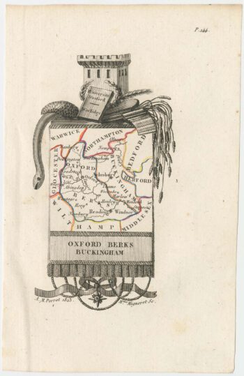
Miniature map of Oxfordshire and Buckinghamshire
£100PERROT, Aristide Michel.
Published In 1828
Stock No. 23133