Showing 1–12 of 503 results
-

A geological map of the Duchy of Tyrol
£2,350STOTTER, Michael.
Published In 1851
Stock No. 23050 -

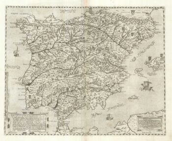
A two-sheet ‘Lafreri-School’ important map of Iberia
£9,750FORLANI, Paolo.
Published In 1567
Stock No. 24477 -

A 17th century chart of the eastern Mediterranean in fine colour.
£1,600DE WIT, Frederick.
Published In 1745
Stock No. 24490 -

de Hooghe’s spectacular chart of the Mediterranean Sea
£36,500HOOGHE, Romeyn de.
Published In 1694
Stock No. 24488 -

Uncommon 16th century Italian map of Cyprus
£1,600ROSACCIO, Giuseppe.
Published In 1598
Stock No. 24538 -

A rare lifetime printing of Blaeu’s view of Vesuvius erupting in 1631
£1,400BLAEU, Johannes.
Published In 1663
Stock No. 24506 -

A map of the early Church in Egypt and Lybia
£650SANSON, Nicolas.
Published In 1704
Stock No. 24115 -

An 18th century city map and prospect of Florence
£1,350HOMANN HEIRS.
Published In 1731
Stock No. 24446 -

Miniature map of Cyprus and the islands of the Aegean
£350HONDIUS, Jodocus II.
Published In 1610
Stock No. 24510 -

A 16th century Italian plan of Cairo
£250VALEGIO, Francesco.
Published In 1598
Stock No. 24146 -

A ‘bird’s-eye’ map of the Gordon Relief Mission, 1884
£1,750BACON, George Washington.
Published In 1885
Stock No. 24107 -

One of the largest printed prospects of Rome
£15,000VASI, Giuseppe.
Published In 1765
Stock No. 24364