Showing 1–12 of 60 results
-

Victorian map of China with views of Hong Kong and Canton
£250TALLIS, John.
Published In 1851
Stock No. 23537 -

A pictorial map of Beijing in the 1930s
£3,000DORN, Frank.
Published In 1936
Stock No. 24392 -

The map of China from the first English atlas of the world
£3,700SPEED, John.
Published In 1665
Stock No. 23978 -

19th century Spanish sea chart of the Yellow Sea and Korea
£2,200BRYANT, Tomas.
Published In 1866
Stock No. 12450 -

A 19th century American sea chart of Hong Kong
£3,500BREWER, H.G.
Published In 1916
Stock No. 23973 -

A detailed map of Victoria in the 1930s
£4,500WAR OFFICE.
Published In 1930
Stock No. 23458 -

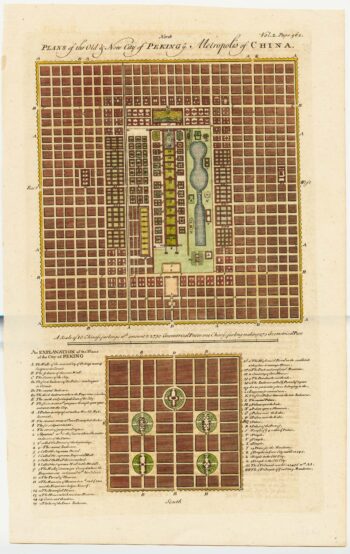
18th century town plan of Peking
£450HARRIS, John.
Published In 1748
Stock No. 23674 -
A 16th century Italian plan of Hangzhou
£650VALEGIO, Francesco.
Published In 1598
Stock No. 24153 -

A charming 17th century miniature account of China.
£650TRIGAULT, Nicolas et al.
Published In 1639
Stock No. 23892 -

An 18th century town plan of Canton in China
£350HARRIS, John.
Published In 1746
Stock No. 23675 -

A mid-18th century map of Taiwan
£360BELLIN, Jacques-Nicolas.
Published In 1748
Stock No. 23668 -

A classic 17th century map of China
£2,500HONDIUS, Jodocus.
Published In 1623
Stock No. 23659