Showing 1–12 of 339 results
-

A map illustrating the British dominance of the seas
£450LONDON GEOGRAPHICAL INSTITUTE.
Published In 1922
Stock No. 24508 -

The Peutinger Table, one of the few surviving examples of Roman cartography
£2,000JANSSON, Jan.
Published In 1700
Stock No. 24492 -

Four scarce Italian playing cards depicting Norway
£850Anonymous.
Published In 1790
Stock No. 24246 -

A scarce 17th century prospect of Villefranche-sur-Mer
£1,500BLAEU, Johannes.
Published In 1682
Stock No. 24159 -

A miniature double-hemisphere world.
£600SANSON, Nicolas.
Published In 1735
Stock No. 22316 -

A 16th century woodcut map of Greece
£380MUNSTER, Sebastian.
Published In 1572
Stock No. 24576 -

Chart of the Zodiac sign Cancer
£275BLUNT, Charles F.
Published In 1845
Stock No. 24288 -

A 16th century town plan of Rhodes
£250ROTA, Martin.
Published In 1598
Stock No. 24199 -

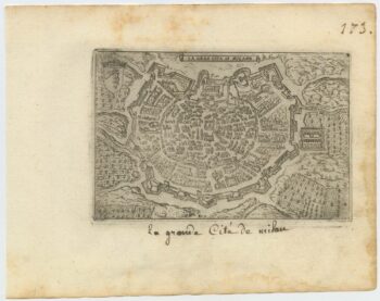
A 16th century town plan of Milan
£240VALEGIO, Francesco.
Published In 1598
Stock No. 24196 -

A 16th century town plan of Toledo
£250VALEGIO, Francesco.
Published In 1598
Stock No. 24189 -

A 16th century town plan of Santander
£260VALEGIO, Francesco.
Published In 1598
Stock No. 24188 -

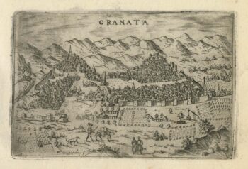
A 16th century town plan of Granada
£270VALEGIO, Francesco.
Published In 1598
Stock No. 24187