Showing 1–12 of 325 results
-

A geological map of the Duchy of Tyrol
£2,350STOTTER, Michael.
Published In 1851
Stock No. 23050 -

An early 19th century map of Cornwall
£225CARY, John.
Published In 1805
Stock No. 24114 -

A two-sheet map of North America
£2,950JAILLOT, Alexis-Hubert.
Published In 1705
Stock No. 24062 -

A two-sheet map of North America
£2,250JAILLOT, Alexis-Hubert.
Published In 1674
Stock No. 24482 -

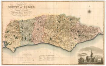
A large scale map of Sussex in fine colour
£2,800GREENWOOD, C. & J.
Published In 1825
Stock No. 24224 -

A large scale map of Nottinghamshire in fine colour
£1,800SANDERSON, George.
Published In 1836
Stock No. 24067 -

An extremely rare example of the first printed plan of Exeter
£4,500HOOKER, John.
Published In 1587
Stock No. 24437 -

A large scale map of Westmorland in fine colour
£1,500GREENWOOD, C. & J.
Published In 1824
Stock No. 24069 -

A large scale map of Warwickshire in fine colour
£1,600GREENWOOD, C. & J.
Published In 1822
Stock No. 24068 -

A large scale map of Nottinghamshire in fine colour
£2,000GREENWOOD, C. & J.
Published In 1826
Stock No. 24066 -

A large scale map of Leicestershire in fine colour
£2,200GREENWOOD, C. & J.
Published In 1826
Stock No. 24064 -

A rare Italian edition of Hennepin’s landmark map of Louisiana
£2,800HENNEPIN, Louis.
Published In 1691
Stock No. 24027