Showing 1–12 of 41 results
-

A large scale map of Nottinghamshire in fine colour
£1,800SANDERSON, George.
Published In 1836
Stock No. 24067 -

A large scale map of Nottinghamshire in fine colour
£2,000GREENWOOD, C. & J.
Published In 1826
Stock No. 24066 -

Miniature map of Nottinghamshire and Derbyshire
£65PERROT, Aristide Michel.
Published In 1828
Stock No. 23301 -

A 17th century map of Nottinghamshire
£500SPEED, John.
Published In 1676
Stock No. 24035 -

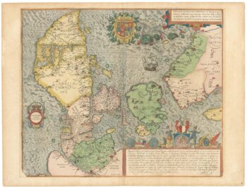
A superb 16th century map of Denmark
£2,000JORDAN, Mark.
Published In 1588
Stock No. 23838 -

A scarce 16th century map of the South Pole and the Strait of Magellan
£3,000WYTFLIET, Cornelis van.
Published In 1597
Stock No. 23439 -

A separately-issued map of Denmark, the earliest dated map by de Wit
£750DE WIT, Frederick.
Published In 1659
Stock No. 23255 -

A 17th century map of the early exploration of the Arctic Circle
£1,250BLAEU, Johannes.
Published In 1662
Stock No. 23200 -

An early 19th century map of Denmark in fine colour
£160LAURIE & WHITTLE.
Published In 1801
Stock No. 22819 -

Martin Frobisher’s voyage in search of the North West Passage
£650AA, Pieter van der.
Published In 1714
Stock No. 22079 -

The scarce Dublin edition of Cook’s map of the Southern Hemisphere
£1,200COOK, James.
Published In 1777
Stock No. 21960 -

A 17th century Dutch sea chart of the North Atlantic
£1,350GOOS, Pieter.
Published In 1670
Stock No. 21871