Showing 1–12 of 23 results
-

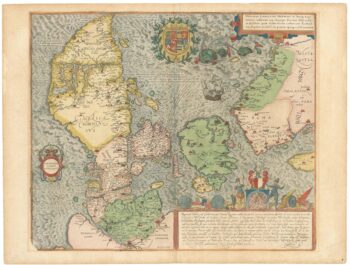
A superb 16th century map of Denmark
£2,000JORDAN, Mark.
Published In 1588
Stock No. 23838 -

A separately-issued map of Denmark, the earliest dated map by de Wit
£750DE WIT, Frederick.
Published In 1659
Stock No. 23255 -

An early 19th century map of Denmark in fine colour
£160LAURIE & WHITTLE.
Published In 1801
Stock No. 22819 -

A 17th century townplan of Dover
£120HERMANNIDES, Rutger.
Published In 1661
Stock No. 22789 -

Early bird’s-eye map-view of Canterbury
£900BRAUN, Georg & HOGENBERG, Frans.
Published In 1588
Stock No. 22168 -

A mid 19th century map of Denmark with decorative vignettes
£125TALLIS, John.
Published In 1851
Stock No. 21622 -

Scarce map of Denmark
£400WALCH, Johann.
Published In 1820
Stock No. 21119 -

17th century map of Denmark
£475VISSCHER, Nicolas Jansz.
Published In 1670
Stock No. 20730 -

Portrait of Christopher Columbus
£80PASSE, C.
Published In 1700
Stock No. 19366 -

A scarce playing-card map of Kent
£500ALLEN, Joseph.
Published In 1811
Stock No. 18725 -

Map of Denmark
£50WILKINSON, Robert.
Published In 1828
Stock No. 17580 -

Portrait of Cook from his ‘Voyage Towards the South Pole’
£275HODGES, William.
Published In 1775
Stock No. 17110