Showing 1–12 of 18 results
-

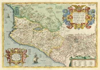
A 16th century map of the colony of New Spain
£750ORTELIUS, Abraham.
Published In 1584
Stock No. 24448 -

An extremely rare example of the first printed plan of Exeter
£4,500HOOKER, John.
Published In 1587
Stock No. 24437 -

Miniature map of Devon
£80PERROT, Aristide Michel.
Published In 1828
Stock No. 23303 -

A scarce issue of John Speed’s map of Devon
£1,100SPEED, John.
Published In 1611
Stock No. 24038 -
18th century plan of Paris in the decade before the French Revolution
£850ALIBERT, Jean.
Published In 1780
Stock No. 23420 -

A mid-19th century tourist’s map of Paris
£400Anonymous.
Published In 1842
Stock No. 22987 -

Mid-17th century map of Mexico
£950SANSON, Nicolas.
Published In 1658
Stock No. 22742 -

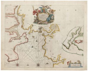
Sea chart of Plymouth from the first English sea-atlas
£450COLLINS, Greenvile.
Published In 1693
Stock No. 21702 -

Paris and surrounding areas in the mid 19th century
£900CHARLE, Jean Baptiste Louis.
Published In 1841
Stock No. 20904 -
A large plan of Paris during the Rise of Napoleon
£1,000ROBERT DE VAUGONDY, Didier.
Published In 1797
Stock No. 20620 -

A detailed Victorian plan of Plymouth
£120TALLIS, John.
Published In 1851
Stock No. 17732 -

The environs of Paris in the early 19th century
£750BASSET, Paul Andre.
Published In 1822
Stock No. 17172