Showing 1–12 of 32 results
-

A two-sheet map of North America
£2,950JAILLOT, Alexis-Hubert.
Published In 1705
Stock No. 24062 -

A two-sheet map of North America
£2,250JAILLOT, Alexis-Hubert.
Published In 1674
Stock No. 24482 -

A rare Italian edition of Hennepin’s landmark map of Louisiana
£2,800HENNEPIN, Louis.
Published In 1691
Stock No. 24027 -

A large and decorative map of Corfu
£750CORONELLI, Vincenzo Maria.
Published In 1690
Stock No. 24095 -

The European colonies in North America in the 18th century
£1,400SEUTTER, Matthaus.
Published In 1735
Stock No. 24089 -

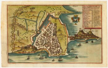
Rare town-plan of Corfu under siege by the Ottomans
£340WIERING, Thomas von.
Published In 1716
Stock No. 23665 -

An 18th century chart of Corfu
£110ROUX, Joseph.
Published In 1804
Stock No. 23636 -

A Dutch edition of rhe first printed map to accurately plot the Mississippi River
£1,700DELISLE, Guillaume.
Published In 1722
Stock No. 23463 -

An 18th century prospect of Corfu city
£150SALMON, Thomas.
Published In 1759
Stock No. 23408 -

The first issue of an important map of North America
£6,500HONDIUS, Henricus.
Published In 1636
Stock No. 22862 -
A map of North America during the Mississippi Bubble
£2,400CHATELAIN, Henri Abraham.
Published In 1718
Stock No. 22751 -

Grierson’s version of Moll’s two-sheet map of the French claims in North America
£8,000MOLL, Herman.
Published In 1735
Stock No. 22697