Showing 1–12 of 16 results
-

18th century plan of Stockholm
£220KITCHIN, Thomas.
Published In 1784
Stock No. 20454 -

Five scarce Italian playing cards depicting Sweden and the Baltic
£700Anonymous.
Published In 1790
Stock No. 24237 -

A 16th century town plan of Stockholm
£350VALEGIO, Francesco.
Published In 1598
Stock No. 24177 -
A scarce 16th century map of the South Pole and the Strait of Magellan
£3,000WYTFLIET, Cornelis van.
Published In 1597
Stock No. 23439 -

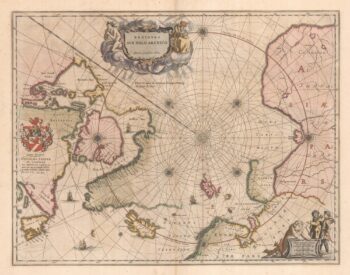
A 17th century map of the early exploration of the Arctic Circle
£1,250BLAEU, Johannes.
Published In 1662
Stock No. 23200 -

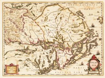
17th century Dutch map of Upland, marking Stockholm
£450HONDIUS, Henricus.
Published In 1647
Stock No. 22704 -

Martin Frobisher’s voyage in search of the North West Passage
£650AA, Pieter van der.
Published In 1714
Stock No. 22079 -

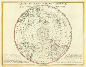
The scarce Dublin edition of Cook’s map of the Southern Hemisphere
£1,200COOK, James.
Published In 1777
Stock No. 21960 -

A 17th century Dutch sea chart of the North Atlantic
£1,350GOOS, Pieter.
Published In 1670
Stock No. 21871 -

A 16th century miniature map of Elba
£200LANGENES, Barent.
Published In 1599
Stock No. 21362 -

A plan of Stockholm, one of William Hogarth’s earliest etchings
£600HOGARTH, William.
Published In 1724
Stock No. 20653 -

Pair of 18th century maps of the North & South hemispheres
£800ZATTA, Antonio.
Published In 1779
Stock No. 19315