Showing 1–12 of 124 results
-
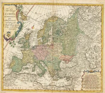
18th century map of Europe
£440EULER, Leonhard.
Published In 1760
Stock No. 24111 -

First issue of Rumold Mercator’s map of Europe
£2,500MERCATOR, Rumold.
Published In 1595
Stock No. 24298 -

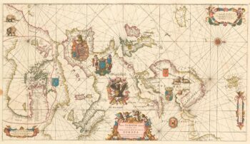
An exceptional 17th century sea chart of Europe on two sheets
£7,500DE WIT, Frederick.
Published In 1675
Stock No. 23450 -

A two-sheet map of Europe
£1,000JAILLOT, Alexis-Hubert.
Published In 1705
Stock No. 24059 -

A 17th century map of the Roman Empire
£1,600SPEED, John.
Published In 1627
Stock No. 23989 -

18th century illustration of a sundial
£160THOMAS, Corbinianus.
Published In 1730
Stock No. 21490 -

One of the earliest versions of Sophianos’s map of Greece
£14,000BERTELLI, Ferrando
Published In 1564
Stock No. 24220 -

17th century English carte ? figure map of Europe
£2,600SPEED, John.
Published In 1665
Stock No. 23986 -

Read’s map of Napoleon’s exile on St Helena, Second State
£1,200READ, R.P.
Published In 1817
Stock No. 22662 -

Napoleon in exile on St Helena
£1,400READ, R.P.
Published In 1815
Stock No. 22661 -
Read’s map of Napoleon’s exile on St Helena, First State
£1,200READ, R.P.
Published In 1815
Stock No. 22660 -

A decorative 18th century map of Greece
£500SEUTTER, Matthaus.
Published In 1750
Stock No. 22308