Showing 1–12 of 32 results
-
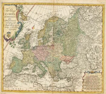
18th century map of Europe
£440EULER, Leonhard.
Published In 1760
Stock No. 24111 -

First issue of Rumold Mercator’s map of Europe
£2,500MERCATOR, Rumold.
Published In 1595
Stock No. 24298 -

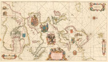
An exceptional 17th century sea chart of Europe on two sheets
£7,500DE WIT, Frederick.
Published In 1675
Stock No. 23450 -

A two-sheet map of Europe
£1,000JAILLOT, Alexis-Hubert.
Published In 1705
Stock No. 24059 -

A 17th century map of the Roman Empire
£1,600SPEED, John.
Published In 1627
Stock No. 23989 -

17th century English carte ? figure map of Europe
£2,600SPEED, John.
Published In 1665
Stock No. 23986 -

A classic early decorative map of Europe
£1,100ORTELIUS, Abraham.
Published In 1598
Stock No. 23861 -

Mid 19th century map of Europe with decorative vignettes
£180TALLIS, John.
Published In 1851
Stock No. 23487 -

An 18th century map of Europe
£500CHATELAIN, Henri Abraham.
Published In 1718
Stock No. 23391 -

A mid-18th century map of Europe showing the spread of religions
£650HAAS, Johann Matthias.
Published In 1743
Stock No. 23322 -

An early 18th century map of Catholic Europe
£600SCHERER, Heinrich.
Published In 1700
Stock No. 23250 -

An early 18th century map of Catholic Europe
£600SCHERER, Heinrich.
Published In 1700
Stock No. 23249