Showing 1–12 of 40 results
-

The First Edition of Ortelius’s map of the Spice Islands
£4,000ORTELIUS, Abraham.
Published In 1570
Stock No. 24431 -

Dutch broadsheet of the Anglo-Spanish War, 1727-9
£900LETH, Andries de.
Published In 1727
Stock No. 22698 -

18th century English map of the East Indies
£440BOWEN, Emanuel.
Published In 1752
Stock No. 21763 -

Early 18th century map of the East Indies
£980DELISLE, Guillaume.
Published In 1705
Stock No. 23907 -

Rare map of the interests of the V.O.C. in the East Indies
£1,650RENNEVILLE, Ren? Auguste Constantin.
Published In 1725
Stock No. 22933 -

A scarce edition of Speed’s map of the Isle of Wight
£800SPEED, John.
Published In 1665
Stock No. 23823 -

17th century English map of the East Indies
£2,200SPEED, John.
Published In 1676
Stock No. 23799 -

A mid-18th century map of Taiwan
£360BELLIN, Jacques-Nicolas.
Published In 1748
Stock No. 23668 -
One of the earliest sea charts to show any part of Australia
£1,600HONDIUS, Henricus.
Published In 1650
Stock No. 23620 -

A striking four-sheet wall map of the Far East
£4,500OTTENS, Joachim.
Published In 1792
Stock No. 23571 -

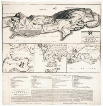
The British capture of Gibraltar in 1704
£800DECKER, Paul.
Published In 1720
Stock No. 23319 -

The scarce second Galle plate for the Far East used in the ‘Epitome’
£450ORTELIUS, Abraham.
Published In 1598
Stock No. 23197