Showing 1–12 of 32 results
-

The First Edition of Ortelius’s map of the Spice Islands
£4,000ORTELIUS, Abraham.
Published In 1570
Stock No. 24431 -

18th century English map of the East Indies
£440BOWEN, Emanuel.
Published In 1752
Stock No. 21763 -

Early 18th century map of the East Indies
£980DELISLE, Guillaume.
Published In 1705
Stock No. 23907 -

Rare map of the interests of the V.O.C. in the East Indies
£1,650RENNEVILLE, Ren? Auguste Constantin.
Published In 1725
Stock No. 22933 -

17th century English map of the East Indies
£2,200SPEED, John.
Published In 1676
Stock No. 23799 -

The famous map of Leinster by John Speed
£750SPEED, John.
Published In 1665
Stock No. 23786 -
One of the earliest sea charts to show any part of Australia
£1,600HONDIUS, Henricus.
Published In 1650
Stock No. 23620 -

A striking four-sheet wall map of the Far East
£4,500OTTENS, Joachim.
Published In 1792
Stock No. 23571 -

The scarce second Galle plate for the Far East used in the ‘Epitome’
£450ORTELIUS, Abraham.
Published In 1598
Stock No. 23197 -

Sea chart of south east Ireland with an inset of Dublin Bay
£550SELLER, Jeremiah.
Published In 1750
Stock No. 23160 -

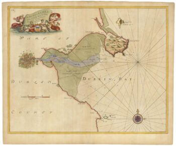
Sea chart of Dublin Bay from the first English sea-atlas
£550COLLINS, Greenvile.
Published In 1693
Stock No. 23156 -

A 17th century map of the trading empire of the Dutch East India Company
£1,650BLAEU, Willem Janszoon.
Published In 1650
Stock No. 22918