Showing 1–12 of 270 results
-

A large and detailed 19th century map of India
£750WALKER, John.
Published In 1829
Stock No. 24543 -

A map illustrating the British dominance of the seas
£450LONDON GEOGRAPHICAL INSTITUTE.
Published In 1922
Stock No. 24508 -

The Peutinger Table, one of the few surviving examples of Roman cartography
£2,000JANSSON, Jan.
Published In 1700
Stock No. 24492 -

A scarce 17th century prospect of Villefranche-sur-Mer
£1,500BLAEU, Johannes.
Published In 1682
Stock No. 24159 -

A miniature double-hemisphere world.
£600SANSON, Nicolas.
Published In 1735
Stock No. 22316 -

A 17th century map of of the Mogol Empire
£700CANTELLI DA VIGNOLA, Giacomo.
Published In 1683
Stock No. 24609 -

16th century woodblock map of France
£380MUNSTER, Sebastian.
Published In 1572
Stock No. 24580 -

A detailed map of Northern India
£300TARDIEU, Ambroise.
Published In 1780
Stock No. 24559 -

An early 19th century map of India.
£240POIRSON, J.B.
Published In 1803
Stock No. 24554 -

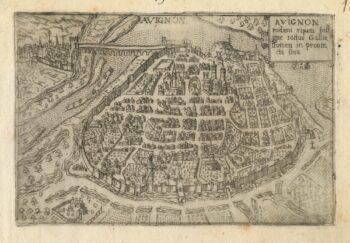
A 16th century town plan of Avignon
£150VALEGIO, Francesco.
Published In 1598
Stock No. 24211 -
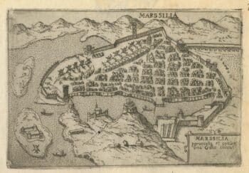
A 16th century town plan of Marseilles
£200VALEGIO, Francesco.
Published In 1598
Stock No. 24210 -

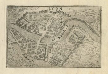
A 16th century town plan of Lyon
£150VALEGIO, Francesco.
Published In 1598
Stock No. 24209