Showing 1–12 of 47 results
-

The most important prospect of Brescia
£18,000CARBONI, Domenico.
Published In 1764
Stock No. 23648 -

A large four-sheet map of Midlothian
£750KNOX, James.
Published In 1821
Stock No. 23326 -

Dutch broadsheet of the Anglo-Spanish War, 1727-9
£900LETH, Andries de.
Published In 1727
Stock No. 22698 -

A Georgian folding map of Linlithgowshire
£800FORREST, William.
Published In 1818
Stock No. 22680 -
The only map by Timothy Pont published in his lifetime
£450PONT, Timothy.
Published In 1638
Stock No. 23842 -

A detailed early 19th century plan of Milan
£450TUA, Antonio.
Published In 1840
Stock No. 23942 -

A 16th century map of the province of Cremona in fine colour.
£500ORTELIUS, Abraham.
Published In 1595
Stock No. 23813 -

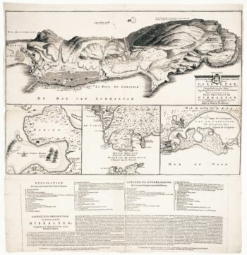
The British capture of Gibraltar in 1704
£800DECKER, Paul.
Published In 1720
Stock No. 23319 -

Dutch sea chart of the harbour of Gibraltar
£450KEULEN, Johannes van.
Published In 1630
Stock No. 22708 -

A four-sheet map of Georgian Stirlingshire
£1,500GRASSOM, John.
Published In 1817
Stock No. 22658 -

Miniature map of Wigtown and Kirkcudbrightshire
£90PERROT, Aristide Michel.
Published In 1828
Stock No. 23117 -

Miniature map of Rossshire
£95PERROT, Aristide Michel.
Published In 1828
Stock No. 23115