Showing 1–12 of 164 results
-

A late Victorian plan of Brighton.
£1,100TREACHER, H. & C.
Published In 1890
Stock No. 24546 -

A map illustrating the British dominance of the seas
£450LONDON GEOGRAPHICAL INSTITUTE.
Published In 1922
Stock No. 24508 -

The Peutinger Table, one of the few surviving examples of Roman cartography
£2,000JANSSON, Jan.
Published In 1700
Stock No. 24492 -

A miniature double-hemisphere world.
£600SANSON, Nicolas.
Published In 1735
Stock No. 22316 -

A 16th century woodcut map of Greece
£380MUNSTER, Sebastian.
Published In 1572
Stock No. 24576 -

A 16th century town plan of Rhodes
£250ROTA, Martin.
Published In 1598
Stock No. 24199 -

A 16th century town plan of Corfu City
£250VALEGIO, Francesco.
Published In 1598
Stock No. 24181 -

A 16th century town plan of Heraklion
£150VALEGIO, Francesco.
Published In 1598
Stock No. 24180 -

A serio-comic map satirising Ronald Reagan’s view of the World
£650HORSEY, David.
Published In 1984
Stock No. 24474 -

The famous scene the Virginians’ Manner of Dancing at their Religious Festivals
£1,900WHITE, John.
Published In 1619
Stock No. 24424 -

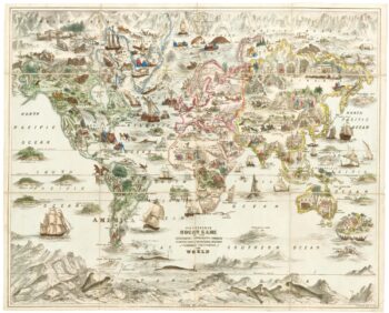
A Victorian game map of the world.
£5,500JONES, Thomas Henry.
Published In 1845
Stock No. 24423 -

Ruysch’s 1507 world map, with the earliest obtainable depiction of the Americas
£260,000RUYSCH, Johann.
Published In 1507
Stock No. 22807