Showing 1–12 of 122 results
-

A large and detailed 19th century map of India
£750WALKER, John.
Published In 1829
Stock No. 24543 -

A map illustrating the British dominance of the seas
£450LONDON GEOGRAPHICAL INSTITUTE.
Published In 1922
Stock No. 24508 -

A miniature double-hemisphere world.
£600SANSON, Nicolas.
Published In 1735
Stock No. 22316 -

A 17th century map of of the Mogol Empire
£700CANTELLI DA VIGNOLA, Giacomo.
Published In 1683
Stock No. 24609 -

A detailed map of Northern India
£300TARDIEU, Ambroise.
Published In 1780
Stock No. 24559 -

An early 19th century map of India.
£240POIRSON, J.B.
Published In 1803
Stock No. 24554 -

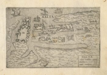
A 16th century town plan of Valletta
£200VALEGIO, Francesco.
Published In 1598
Stock No. 24173 -

A 16th century Italian plan of Kannur, Kerala
£140VALEGIO, Francesco.
Published In 1598
Stock No. 24141 -

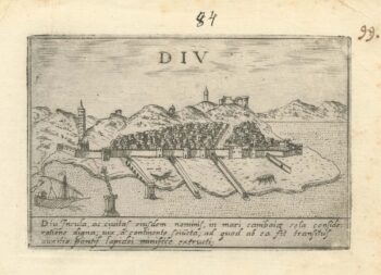
A 16th century Italian plan of Diu Island
£200VALEGIO, Francesco.
Published In 1598
Stock No. 24140 -

A serio-comic map satirising Ronald Reagan’s view of the World
£650HORSEY, David.
Published In 1984
Stock No. 24474 -

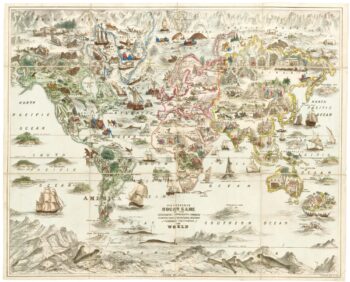
A Victorian game map of the world.
£5,500JONES, Thomas Henry.
Published In 1845
Stock No. 24423 -
Ruysch’s 1507 world map, with the earliest obtainable depiction of the Americas
£260,000RUYSCH, Johann.
Published In 1507
Stock No. 22807