Showing 1–12 of 32 results
-

London in the reign of William IV
£550SMITH, Charles.
Published In 1836
Stock No. 24428 -

Early 19th century plan of London
£350Anonymous.
Published In 1810
Stock No. 24505 -

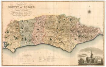
A large scale map of Sussex in fine colour
£2,800GREENWOOD, C. & J.
Published In 1825
Stock No. 24224 -

A Victorian plan of London
£750WYLD, James.
Published In 1859
Stock No. 23945 -

Victorian map of the environs of London
£220MOULE, Thomas.
Published In 1837
Stock No. 23574 -

The Indian Ocean from Ortelius’s ”Parergon”
£950ORTELIUS, Abraham.
Published In 1608
Stock No. 23719 -

Mid-Victorian wall map of London on a scale of 6” to a Mile
£3,500STANFORD, Edward.
Published In 1861
Stock No. 23419 -

An unusual balloon view of Brighton in the 1840s
£650ARNOUT, Jules.
Published In 1846
Stock No. 23159 -

Important 16th century ‘Upside-Down’ map of the Indian Ocean
£9,500GASTALDI, Giacomo.
Published In 1565
Stock No. 22851 -

Early Georgian map of the environs of London
£1,500OVERTON, Henry.
Published In 1720
Stock No. 13522 -

A Dutch chart of the Indian Ocean with Australia
£2,000JANSSON, Jan.
Published In 1650
Stock No. 23581 -

Map of the environs of London with inset views of Royal Palaces
£1,250HOMANN, Johann Baptist.
Published In 1710
Stock No. 23003