Showing 1–12 of 14 results
-

Decorative 18th century map of Norway
£460HOMANN, Johann Baptist.
Published In 1720
Stock No. 24171 -

An 18th century map of the Virgin Islands
£700EDWARDS, Bryan.
Published In 1794
Stock No. 24169 -

The famous map of Leinster by John Speed
£750SPEED, John.
Published In 1665
Stock No. 23786 -

The Muscovy Company whaling at Svalbard
£950EDGE, Thomas.
Published In 1625
Stock No. 23464 -

One of the few early map focusing on Norway
£850DE WIT, Frederick.
Published In 1680
Stock No. 23247 -

Sea chart of south east Ireland with an inset of Dublin Bay
£550SELLER, Jeremiah.
Published In 1750
Stock No. 23160 -

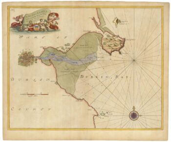
Sea chart of Dublin Bay from the first English sea-atlas
£550COLLINS, Greenvile.
Published In 1693
Stock No. 23156 -

Miniature map of Longford and West Meath
£100PERROT, Aristide Michel.
Published In 1828
Stock No. 23127 -

Miniature map of East Meath
£110PERROT, Aristide Michel.
Published In 1828
Stock No. 23126 -

Miniature map of Dublin
£110PERROT, Aristide Michel.
Published In 1828
Stock No. 23125 -
Miniature map of Kildare
£75PERROT, Aristide Michel.
Published In 1828
Stock No. 23120 -
Miniature map of Kilkenny
£95PERROT, Aristide Michel.
Published In 1828
Stock No. 23119