Showing 1–12 of 75 results
-

A 17th century chart of the eastern Mediterranean in fine colour.
£1,600DE WIT, Frederick.
Published In 1745
Stock No. 24490 -

de Hooghe’s spectacular chart of the Mediterranean Sea
£36,500HOOGHE, Romeyn de.
Published In 1694
Stock No. 24488 -

Uncommon 16th century Italian map of Cyprus
£1,600ROSACCIO, Giuseppe.
Published In 1598
Stock No. 24538 -

A two-sheet map of North America
£2,950JAILLOT, Alexis-Hubert.
Published In 1705
Stock No. 24062 -

A two-sheet map of North America
£2,250JAILLOT, Alexis-Hubert.
Published In 1674
Stock No. 24482 -

Miniature map of Cyprus and the islands of the Aegean
£350HONDIUS, Jodocus II.
Published In 1610
Stock No. 24510 -

A rare Italian edition of Hennepin’s landmark map of Louisiana
£2,800HENNEPIN, Louis.
Published In 1691
Stock No. 24027 -

16th century map with Cyprus & Crete
£900ORTELIUS, Abraham.
Published In 1573
Stock No. 24407 -

The European colonies in North America in the 18th century
£1,400SEUTTER, Matthaus.
Published In 1735
Stock No. 24089 -

A scarce German edition of Pocock’s map of Cyprus
£650POCOCKE, Richard.
Published In 1745
Stock No. 23804 -

The Peregrinations of Saint Paul in superb original colour
£1,400ORTELIUS, Abraham.
Published In 1603
Stock No. 23745 -

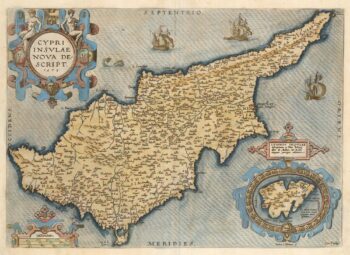
A classic 16th century Dutch map of Cyprus
£1,400ORTELIUS, Abraham.
Published In 1579
Stock No. 23740