Showing 1–12 of 144 results
-

An unusual 18th century map of the Holy Land
£800SEUTTER, Matth?us.
Published In 1745
Stock No. 24605 -

A plan of Jerusalem after Adrichom
£750SEUTTER, Matth?us.
Published In 1730
Stock No. 24600 -

An early woodcut map of the Holy Land
£850MUNSTER, Sebastian.
Published In 1552
Stock No. 24569 -

17th century prospect of Biblical Jerusalem
£1,000DAPPER, Olfert.
Published In 1677
Stock No. 24540 -

16th century Dutch map of Switzerland
£800ORTELIUS, Abraham.
Published In 1575
Stock No. 21809 -

A 16th century woodcut map of Switzerland
£400MUNSTER, Sebastian.
Published In 1572
Stock No. 24570 -

An early 18th century map of the Middle East
£450CHATELAIN, Henri Abraham.
Published In 1720
Stock No. 24551 -

A scarce map of the Holy Land in the 18th century
£250FER, Nicolas de.
Published In 1707
Stock No. 24525 -

A scarce map of the Holy Land in Biblical times
£250FER, Nicolas de.
Published In 1707
Stock No. 24524 -

A 16th century town plan of Tangier
£220VALEGIO, Francesco.
Published In 1598
Stock No. 24217 -

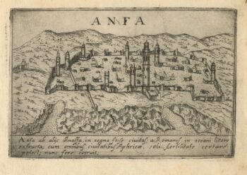
A 16th century town plan of Casablanca
£240VALEGIO, Francesco.
Published In 1598
Stock No. 24215 -

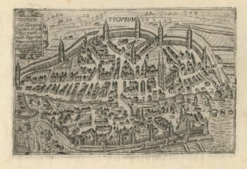
A 16th century town plan of Zurich
£380VALEGIO, Francesco.
Published In 1598
Stock No. 24208