Showing 1–12 of 41 results
-

A map of the early Church in Egypt and Lybia
£650SANSON, Nicolas.
Published In 1704
Stock No. 24115 -

A 16th century Italian plan of Cairo
£250VALEGIO, Francesco.
Published In 1598
Stock No. 24146 -

A ‘bird’s-eye’ map of the Gordon Relief Mission, 1884
£1,750BACON, George Washington.
Published In 1885
Stock No. 24107 -

18th century illustration of a sundial
£160THOMAS, Corbinianus.
Published In 1730
Stock No. 21490 -

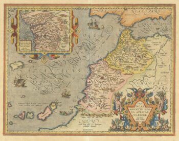
A 16th century map of Morocco
£700ORTELIUS, Abraham.
Published In 1601
Stock No. 23718 -

18th century map of Nubia and Abyssinia
£350CASSINI, Giovanni Maria.
Published In 1798
Stock No. 13313 -

A 17th century illustration of an armillary sphere
£180MALLET, Alain Manesson.
Published In 1683
Stock No. 23928 -

A famous 16th century woodblock map of North Africa
£850WALDSEEMULLER, Martin.
Published In 1541
Stock No. 23837 -

An 18th century illustration of an armillary sphere
£950DESNOS, Louis Charles.
Published In 1781
Stock No. 23289 -

Decorative map of Egypt and the Nile
£450HOMANN, Johann Baptist.
Published In 1725
Stock No. 23263 -

Early 17th century map of central Africa
£200HONDIUS, Jodocus.
Published In 1608
Stock No. 23220 -

Classic 17th century map of Portugal
£480BLAEU, Willem Janszoon.
Published In 1640
Stock No. 22963