Showing 1–12 of 40 results
-

Early map of the roads from Lichfield to Chester
£280OGILBY, John.
Published In 1675
Stock No. 23239 -

A chart of the Hong River, marking Hanoi
£100BELLIN, Jacques-Nicolas.
Published In 1764
Stock No. 20809 -

17th century Illustration of Tunquin
£180TAVERNIER, Jean-Baptiste.
Published In 1678
Stock No. 19921 -

17th century Illustration of King of Tunquin
£160TAVERNIER, Jean-Baptiste.
Published In 1678
Stock No. 19920 -

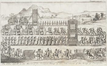
17th century Illustration of Tunquin Dignitaries
£190TAVERNIER, Jean-Baptiste.
Published In 1678
Stock No. 19919 -

17th century Illustration of Temples and Pagodas in Tunquin
£190TAVERNIER, Jean-Baptiste.
Published In 1678
Stock No. 19917 -
17th century Illustration of Temples and Pagodas in Tunquin
£180TAVERNIER, Jean-Baptiste.
Published In 1678
Stock No. 19916 -
Early map of the road from Hereford to Leicester
£200OGILBY, John.
Published In 1675
Stock No. 16364 -

Early map of the roads from Tuxford – York
£220OGILBY, John.
Published In 1675
Stock No. 16363 -

Early road map of the roads from London to Stilton in Cambridgeshire
£280OGILBY, John.
Published In 1675
Stock No. 16325 -

Early map of the roads from Llanbadarn Fynydd to Cardiff
£180OGILBY, John.
Published In 1675
Stock No. 15381 -

Early map of the roads from Carmarthen to Aberystwyth
£280OGILBY, John.
Published In 1675
Stock No. 15377