Showing 13–24 of 2618 results
-

Munster’s famous ‘Upside-down’ map of Europe
£1,350MUNSTER, Sebastian.
Published In 1572
Stock No. 24568 -

An early woodcut map of Scandinavia
£1,100MUNSTER, Sebastian.
Published In 1572
Stock No. 24567 -

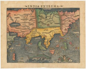
The first printed map of Asia
£1,850MUNSTER, Sebastian.
Published In 1572
Stock No. 24565 -

An early woodcut map of England
£1,000MUNSTER, Sebastian.
Published In 1572
Stock No. 24564 -

Munster’s classic woodcut map of Italy
£850MUNSTER, Sebastian.
Published In 1572
Stock No. 24562 -

The English edition of Du Halde’s map of Guangdong
£1,600DU HALDE, Johann Baptiste.
Published In 1738
Stock No. 24558 -

18th century map of the Eastern Seaboard
£750ROBERT DE VAUGONDY, Didier.
Published In 1770
Stock No. 24555 -

A classic 16th century Dutch map of Italy
£1,400ORTELIUS, Abraham.
Published In 1572
Stock No. 24552 -

A late Victorian plan of Brighton.
£1,100TREACHER, H. & C.
Published In 1890
Stock No. 24546 -

A rare 18th century townplan of Worcester
£2,400YOUNG, George.
Published In 1780
Stock No. 24545 -
A scarce 18th century map of the Polish-Lithuanian Commonwealth
£950NOLIN, Jean Baptiste jnr.
Published In 1742
Stock No. 24544 -

A large and detailed 19th century map of India
£750WALKER, John.
Published In 1829
Stock No. 24543