
A detailed 19th century chart of the south west Pacific
VINCENDON-DUMOULIN, Clement Adrien.
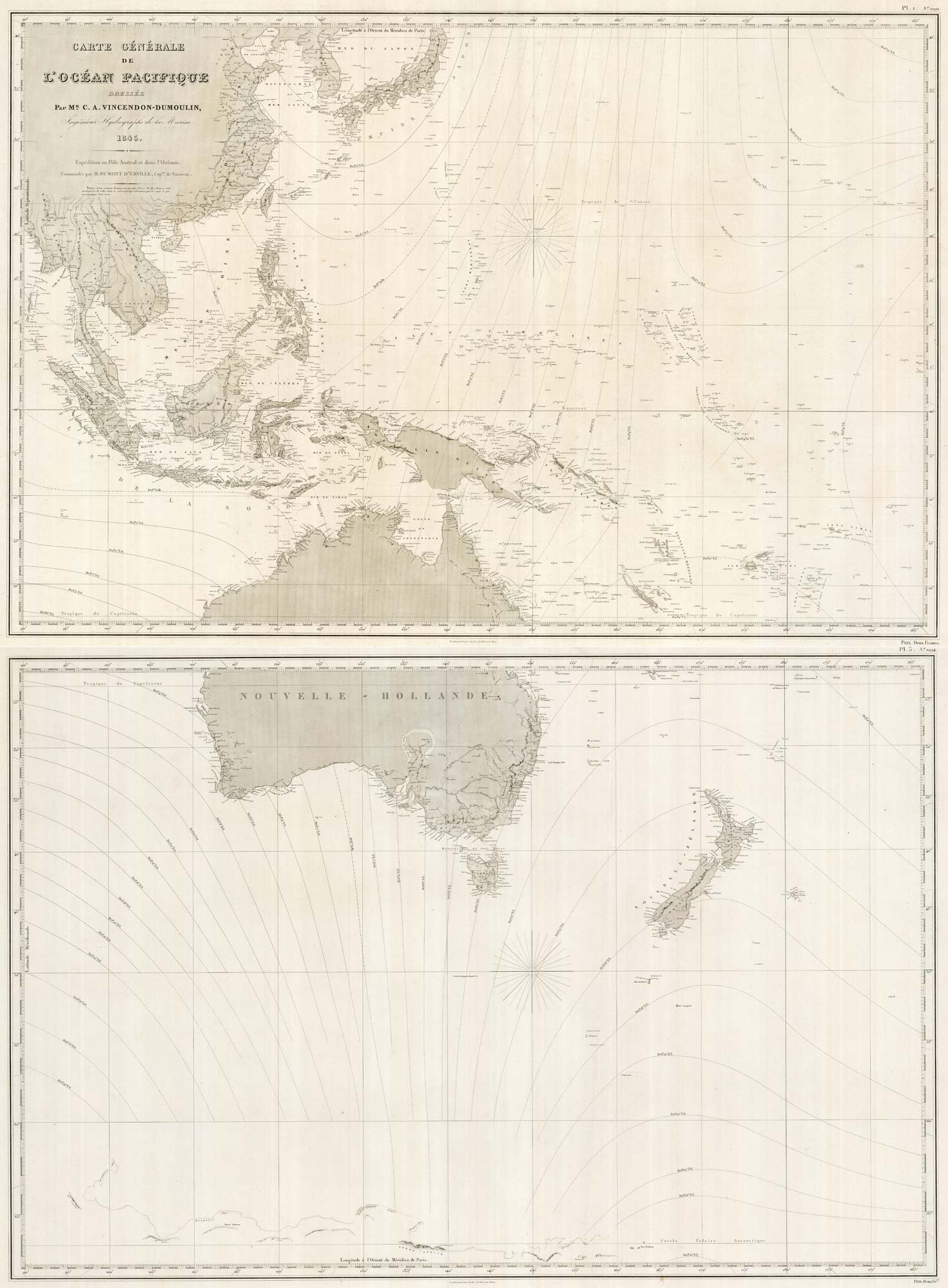
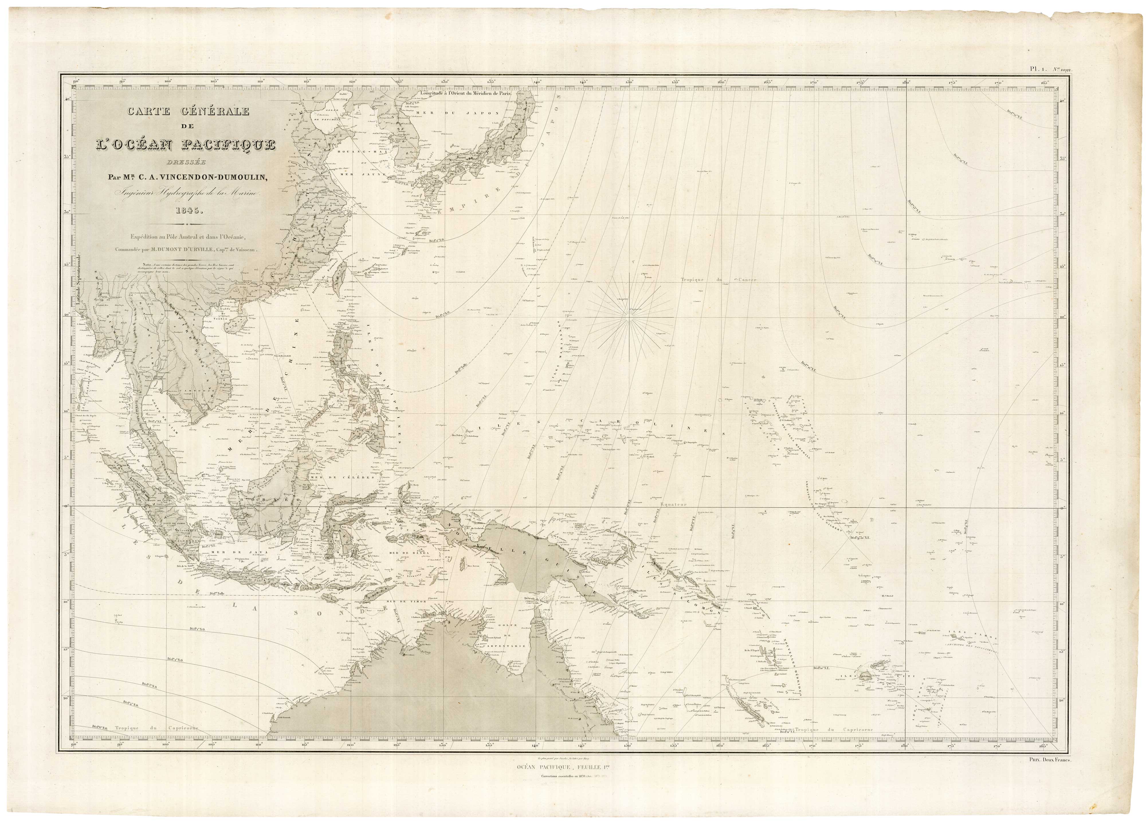
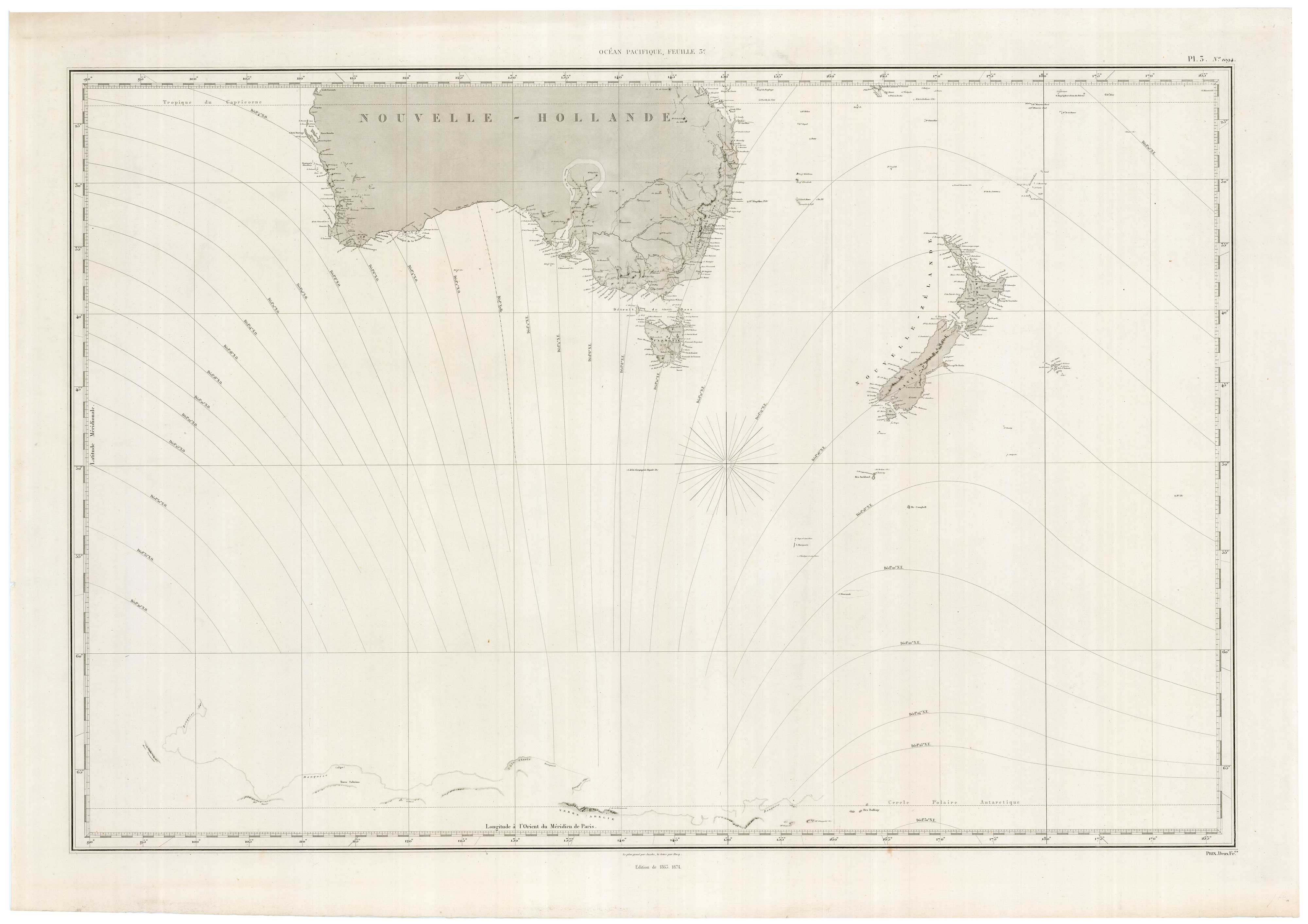
Carte Generale de l'Ocean Pacifique Dressee par Mr. C.A. Vincendon-Dumoulin, Ingenieur Hydrographe de la Marine. 1845. Expédition au Pôle Austral et dans l'Océanie, Commandée par M. Dumont D'Urville, Capt.ne de Vaisseau.
Paris, 1845-74. Two separate-issue sheets, each 720 x 1020mm.
Two sheets, priced separately, of a four sheet map of the Pacific as mapped by the expedition of Jules Dumont d'Urville to find the Magnetic South Pole (1837-40), with 'essential corrctions' to 1874. These are the two western sheets: the upper sheet shows from Burma, Korea and Japan south to northern Australia, Fiji, Tonga and Samoa; the lower sheet has southern Australia (with a 'horseshoe' Torrens Lake), New Zeeland, far to the south, 'Terre Adelie' (named after Dumont's wife) on the coast of Antarctica. Across both maps, as fitting for the expedition's purpose, magnetic declination is shown.
Dumont's ship 'Astrolabe' entered the Pacific via the Strait of Magellan, then turned south, attempting to get further south than Wedell's expedition of 1823. Dumont was more familiar with voyages in the tropics, and his crew suffered in the ice, particularly with scurvy brought on by inadequate food supplies. The expedition needed interludes for recovery, including a stay in Hobart in December 1839. On 1st January 1840 Dumont left Tasmania and headed south, reaching Adelie Land, before heading back towards Hobart on 1st February.
Arriving back in France in November 1840, Dumont was promoted to Rear Admiral and became president of the French Geographical Society. However, in an ironic twist for such an intrepid explorer, Dumont, Adéle and their children were killed in France's first rail disaster, the Versailles Train Crash, in 1842.
Stock ID : 22088
£1,600
£1,600

A detailed 19th century chart of the south west Pacific
VINCENDON-DUMOULIN, Clement Adrien.
Carte Generale de l'Ocean Pacifique Dressee par Mr. C.A. Vincendon-Dumoulin, Ingenieur Hydrographe de la Marine. 1845. Expédition au Pôle Austral et dans l'Océanie, Commandée par M. Dumont D'Urville, Capt.ne de Vaisseau.
Paris, 1845-74. Two separate-issue sheets, each 720 x 1020mm.
Two sheets, priced separately, of a four sheet map of the Pacific as mapped by the expedition of Jules Dumont d'Urville to find the Magnetic South Pole (1837-40), with 'essential corrctions' to 1874. These are the two western sheets: the upper sheet shows from Burma, Korea and Japan south to northern Australia, Fiji, Tonga and Samoa; the lower sheet has southern Australia (with a 'horseshoe' Torrens Lake), New Zeeland, far to the south, 'Terre Adelie' (named after Dumont's wife) on the coast of Antarctica. Across both maps, as fitting for the expedition's purpose, magnetic declination is shown.
Dumont's ship 'Astrolabe' entered the Pacific via the Strait of Magellan, then turned south, attempting to get further south than Wedell's expedition of 1823. Dumont was more familiar with voyages in the tropics, and his crew suffered in the ice, particularly with scurvy brought on by inadequate food supplies. The expedition needed interludes for recovery, including a stay in Hobart in December 1839. On 1st January 1840 Dumont left Tasmania and headed south, reaching Adelie Land, before heading back towards Hobart on 1st February.
Arriving back in France in November 1840, Dumont was promoted to Rear Admiral and became president of the French Geographical Society. However, in an ironic twist for such an intrepid explorer, Dumont, Adéle and their children were killed in France's first rail disaster, the Versailles Train Crash, in 1842.
Stock ID : 22088
£1,600
£1,600


Altea Antique Maps & Charts
Altea Gallery Ltd, 35 St George Street
London
W1S 2FN
United Kingdom
Tel: +44 20 7491 0010
info@alteagallery.com
Sitemap :

