


An 18th century wall map of Africa
ANVILLE, Jean Baptiste B. D'.
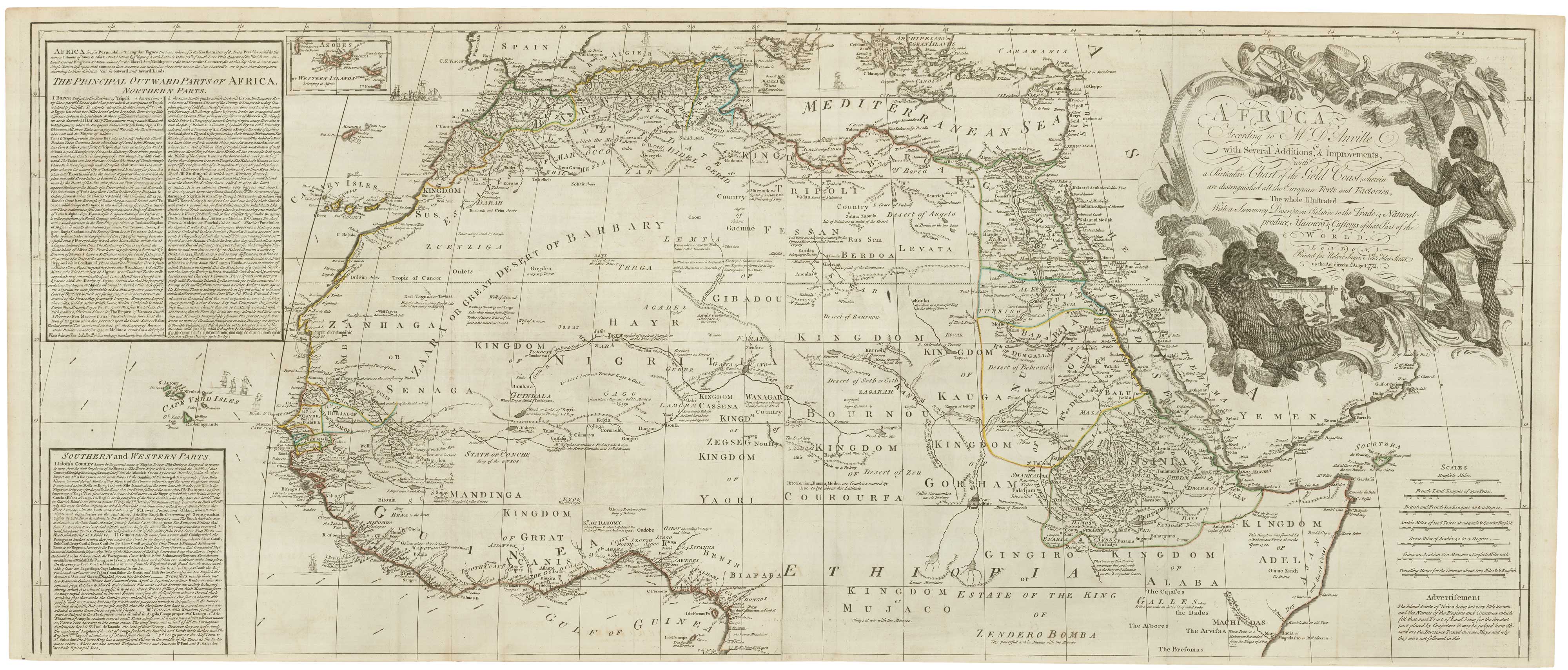
Africa, According to Mr. D'Anville with Several Additions, & Improvements, with a Particular Chart of the Gold Coast; wherein are distinguished all the European Forts and Factories, The whole Illustrated With a Summary Description Relative to the Trade & Natural-Produce, Manners & Customs of that Part of the World.
London: Robert Sayer, 1772. Original outline colour. Four sheets conjoined, total 1045 x 1250mm.
A very fine example of a large and detailed map of Africa (on the coasts at least), with a huge title cartouche of natives killing and earing their enemies. Extensive text boxes describe the trading opprtunities of each region. The text in the inset of the Gold Coast is devoted to gold rather than the other main export of the area, slaves.
See NORWICH: 105 for a later state, erroneously described as two-sheet.
Stock ID : 22567
£1,800
£1,800

An 18th century wall map of Africa
ANVILLE, Jean Baptiste B. D'.
Africa, According to Mr. D'Anville with Several Additions, & Improvements, with a Particular Chart of the Gold Coast; wherein are distinguished all the European Forts and Factories, The whole Illustrated With a Summary Description Relative to the Trade & Natural-Produce, Manners & Customs of that Part of the World.
London: Robert Sayer, 1772. Original outline colour. Four sheets conjoined, total 1045 x 1250mm.
A very fine example of a large and detailed map of Africa (on the coasts at least), with a huge title cartouche of natives killing and earing their enemies. Extensive text boxes describe the trading opprtunities of each region. The text in the inset of the Gold Coast is devoted to gold rather than the other main export of the area, slaves.
See NORWICH: 105 for a later state, erroneously described as two-sheet.
Stock ID : 22567
£1,800
£1,800


Altea Antique Maps & Charts
Altea Gallery Ltd, 35 St George Street
London
W1S 2FN
United Kingdom
Tel: +44 20 7491 0010
info@alteagallery.com
Sitemap :

