
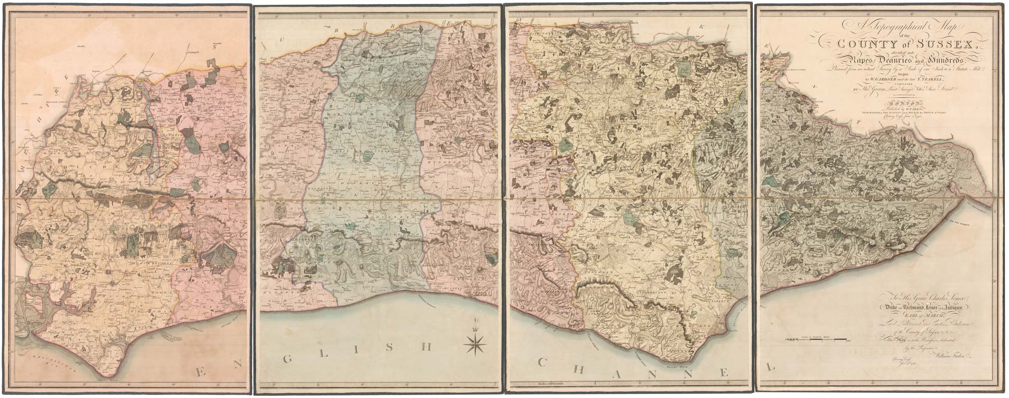
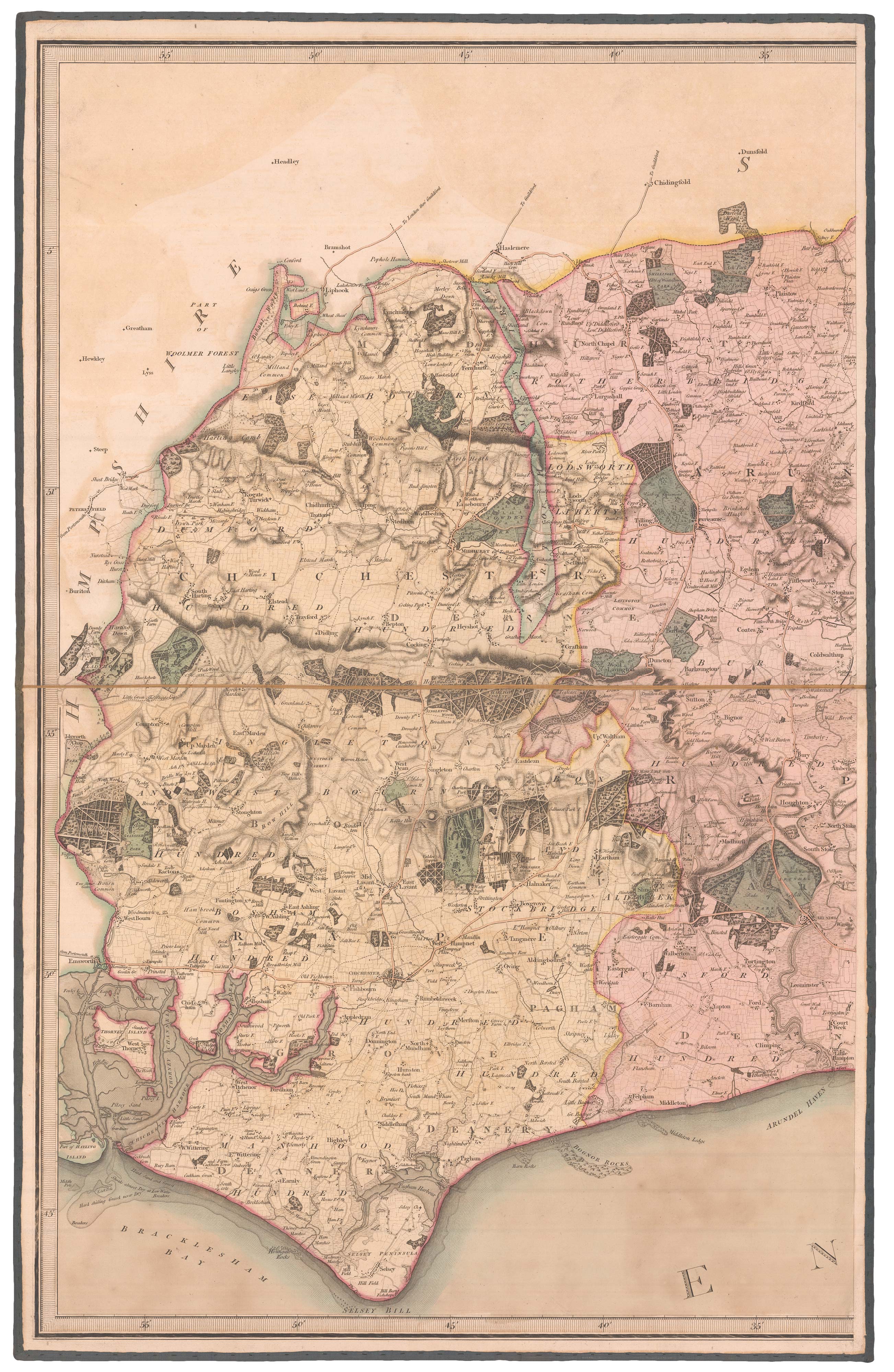
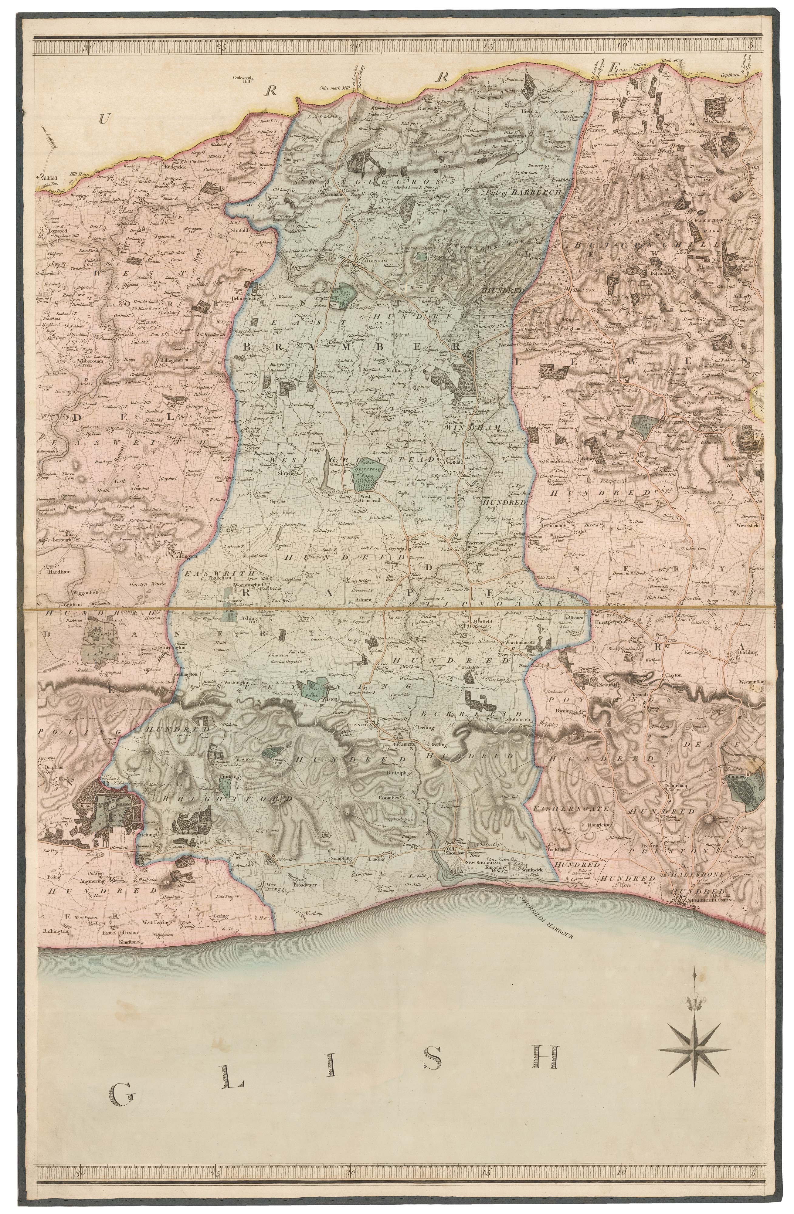
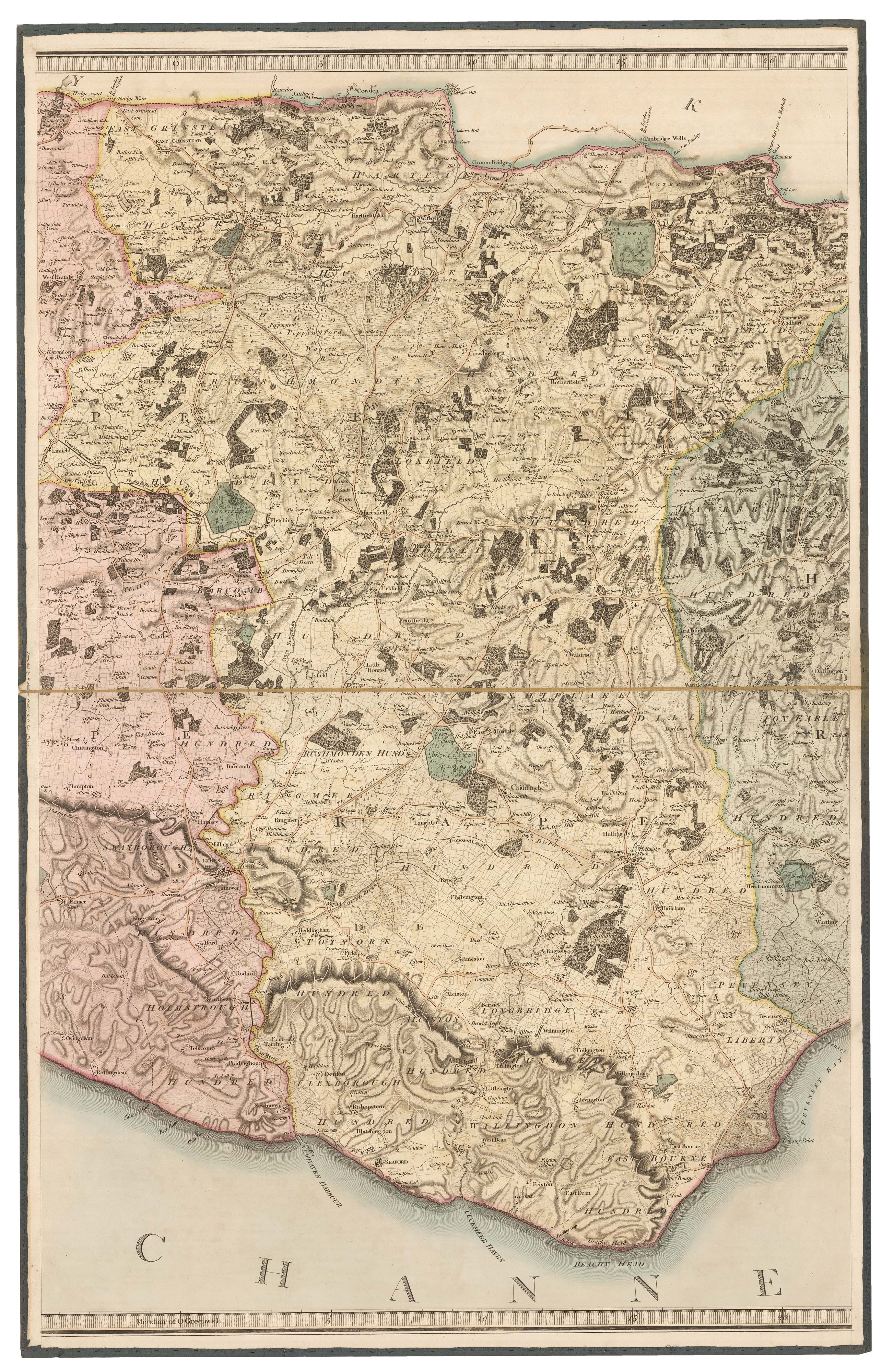
The deluxe edition of an important large scale map of Sussex
GARDNER, William, YEAKELL, Thomas & GREAM, Thomas.
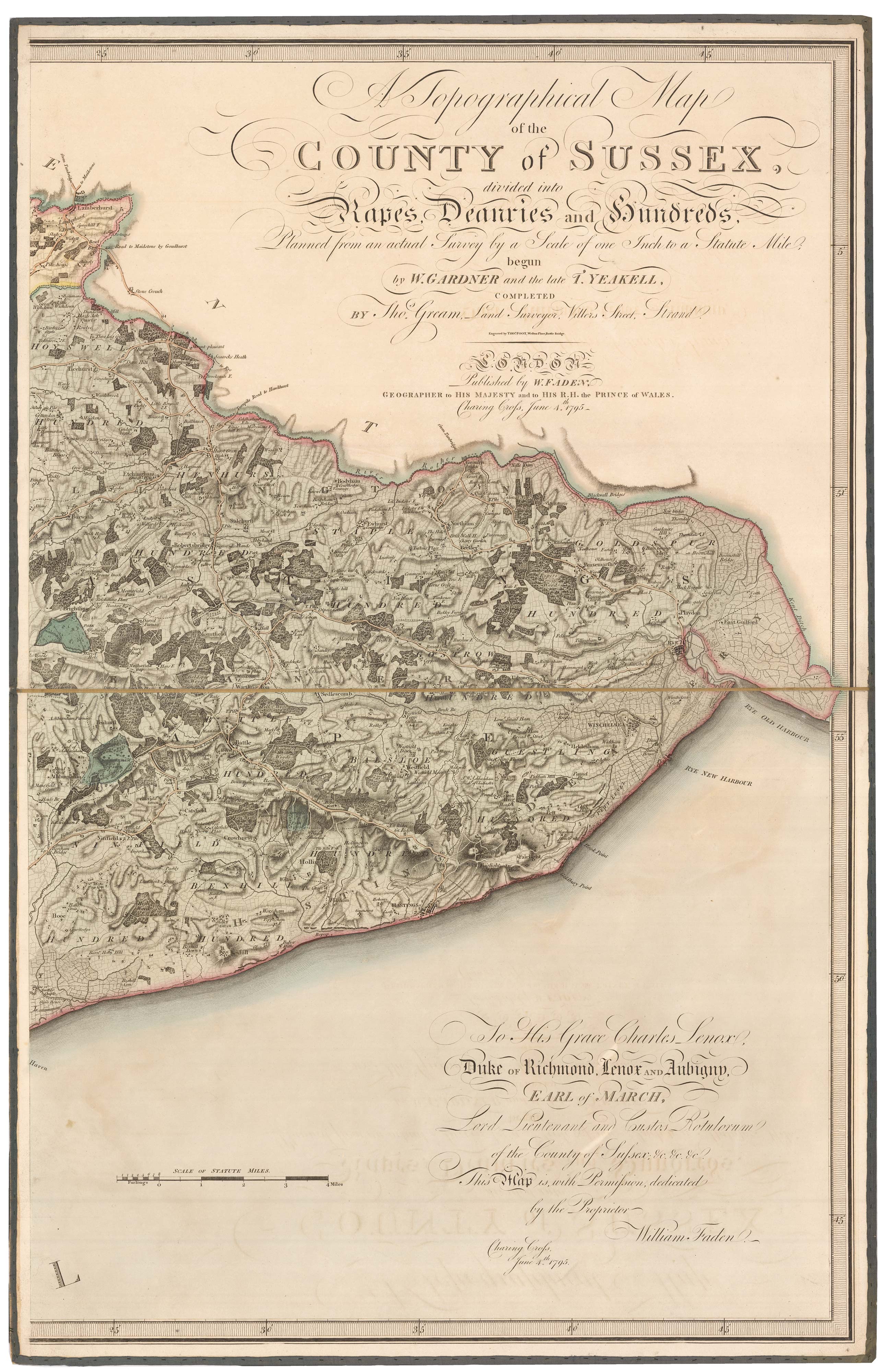
A Topographical Map of the County of Sussex, divided into Rapes, Deanries and hundreds, Planned from an actual Survey by a Scale of one Inch to a Statue Mile; begun by W. Gardner and the late T. Yeakell, Completed by Tho.s Gream, Land Surveyor, Villiers Street, Strand.
London: William Faden, 1795. Fine original body colour. Four sheets, dissected and laid on linen in four sections, edged with silk as issued, each section 805 x 510mm.
Some faint offset.
A large and detailed map of Sussex, important as the first published map of the county using the Board of Ordnance trigonometrical survey.
William Gardner (1739-1800) and Thomas Yeakell (1758-87) originally intended that their survey of Sussex to be on a scale of two inches to a mile, with the eight sheets to be published over six years from 1778. However they needed to sell at least 400 subscriptions to meet the estimated cost of £2,400 but only sold 250, meaning their enterprise folded after the fourth plate was published in 1783, leaving half the county unmapped.
In 1787 Yeakell died and Gardner joined the Ordnance as Chief Surveying Draftsman, although he maintained his private practice. With the encouragement of the Master-General of the Ordnance (Charles Lennox, Duke of Richmond), who allowed him access to William Mudge's trigonometrical survey, Gardner returned to his map of Sussex, working alongside surveyor Thomas Gream to complete it, although on a reduced scale. Their finished map was then engraved by Thomas Foot and published 1795 by William Faden, predating the first OS map (Kent) by six years. Not only did the map win Faden a gold medal from the Society of Arts, but it also became the template for other large scale county maps like the first Ordnance Survey maps and those of John & Christopher Greenwood.
KINGSLEY: 57 state iii, same year as first state.
Stock ID : 22942
£2,000
£2,000

The deluxe edition of an important large scale map of Sussex
GARDNER, William, YEAKELL, Thomas & GREAM, Thomas.
A Topographical Map of the County of Sussex, divided into Rapes, Deanries and hundreds, Planned from an actual Survey by a Scale of one Inch to a Statue Mile; begun by W. Gardner and the late T. Yeakell, Completed by Tho.s Gream, Land Surveyor, Villiers Street, Strand.
London: William Faden, 1795. Fine original body colour. Four sheets, dissected and laid on linen in four sections, edged with silk as issued, each section 805 x 510mm.
Some faint offset.
A large and detailed map of Sussex, important as the first published map of the county using the Board of Ordnance trigonometrical survey.
William Gardner (1739-1800) and Thomas Yeakell (1758-87) originally intended that their survey of Sussex to be on a scale of two inches to a mile, with the eight sheets to be published over six years from 1778. However they needed to sell at least 400 subscriptions to meet the estimated cost of £2,400 but only sold 250, meaning their enterprise folded after the fourth plate was published in 1783, leaving half the county unmapped.
In 1787 Yeakell died and Gardner joined the Ordnance as Chief Surveying Draftsman, although he maintained his private practice. With the encouragement of the Master-General of the Ordnance (Charles Lennox, Duke of Richmond), who allowed him access to William Mudge's trigonometrical survey, Gardner returned to his map of Sussex, working alongside surveyor Thomas Gream to complete it, although on a reduced scale. Their finished map was then engraved by Thomas Foot and published 1795 by William Faden, predating the first OS map (Kent) by six years. Not only did the map win Faden a gold medal from the Society of Arts, but it also became the template for other large scale county maps like the first Ordnance Survey maps and those of John & Christopher Greenwood.
KINGSLEY: 57 state iii, same year as first state.
Stock ID : 22942
£2,000
£2,000


Altea Antique Maps & Charts
Altea Gallery Ltd, 35 St George Street
London
W1S 2FN
United Kingdom
Tel: +44 20 7491 0010
info@alteagallery.com
Sitemap :

