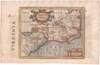
The environs of Chesapeake Bay published in Ogilby's 'America', an English edition of Montanus' 'De Nieuwe En Onbekende Weereld'. Derived from the John Smith map of 1612 it ignores the development of Maryland, and for some reason has a llama and a unicorn in the title cartouche.
The same plate was used for the Dutch edition of the same year, published by Meurs.
Additional information
| Cartographer | |
|---|---|
| Date | 1671 |
| Extra Info | Nova Virginiae Tabula. |
| Publication | London: John Ogilby, 1671. Coloured. 295 x 355mm. |
| Condition | A good example. |
| References | – |
Related Items
Related products
-

Early English chart of the environs of Chesapeake Bay
£3,800THORNTON, John.
Published In 1748
Stock No. 15467 -

Virginia & Florida
£1,350BLAEU, Willem Janszoon.
Published In 1647
Stock No. 10145 -

Virginia and Florida from the first English Edition of the ‘Atlas Minor’
£680HONDIUS, Jodocus.
Published In 1635
Stock No. 22380 -

18th century map of Virginia & Maryland in original colours.
£380BELLIN, Jacques-Nicolas.
Published In 1773
Stock No. 23224