Showing 1–12 of 76 results
-

Blaeu’s classic 17th century map of Iceland
£1,200BLAEU, Willem Janszoon.
Published In 1635
Stock No. 24604 -

A 16th century town plan of Rhodes
£250ROTA, Martin.
Published In 1598
Stock No. 24199 -

The First Edition of Ortelius’s map of the Spice Islands
£4,000ORTELIUS, Abraham.
Published In 1570
Stock No. 24431 -

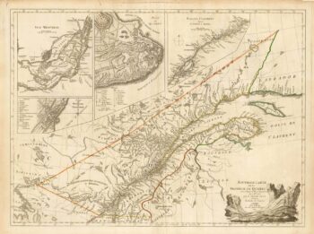
An 18th century ‘vue d’optique’ of Quebec
£750LEIZELT, Balthasar Frederick.
Published In 1775
Stock No. 24523 -

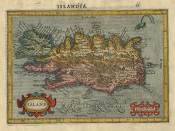
An early 17th century map of Iceland
£350HONDIUS, Jodocus.
Published In 1610
Stock No. 24509 -

A French edition of an important map of the St Lawrence valley
£1,600CARVER, Jonathan.
Published In 1777
Stock No. 23477 -

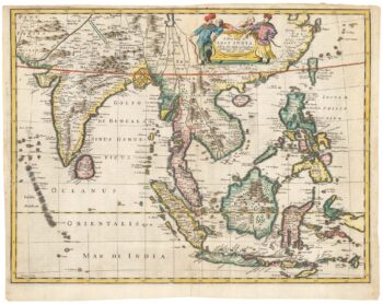
Early 18th century map of the East Indies
£980DELISLE, Guillaume.
Published In 1705
Stock No. 23907 -

Rare map of the interests of the V.O.C. in the East Indies
£1,650RENNEVILLE, Ren? Auguste Constantin.
Published In 1725
Stock No. 22933 -
Rare map of Iceland
£525SAUZET, Henri de.
Published In 1734
Stock No. 23691 -
17th century English map of the East Indies
£2,200SPEED, John.
Published In 1676
Stock No. 23799 -

An uncommon Italian map of Iceland
£420CASSINI, Giovanni Maria.
Published In 1794
Stock No. 23742 -

One of the earliest sea charts to show any part of Australia
£1,600HONDIUS, Henricus.
Published In 1650
Stock No. 23620