Showing 1–12 of 205 results
-

A map of the early Church in Egypt and Lybia
£650SANSON, Nicolas.
Published In 1704
Stock No. 24115 -

Two-sheet map of Africa
£1,200JAILLOT, Alexis-Hubert.
Published In 1705
Stock No. 24063 -

An early 17th century map of Iceland
£350HONDIUS, Jodocus.
Published In 1610
Stock No. 24509 -

A 16th century Italian plan of Cairo
£250VALEGIO, Francesco.
Published In 1598
Stock No. 24146 -

A ‘bird’s-eye’ map of the Gordon Relief Mission, 1884
£1,750BACON, George Washington.
Published In 1885
Stock No. 24107 -

An important 16th century plan of Angra
£2,800LINSCHOTEN, Jan Huygen van.
Published In 1595
Stock No. 23737 -

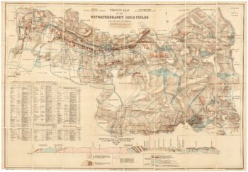
A scarce map of the gold rush near Johannesburg
£1,900TROYE, Gustav Arthur.
Published In 1892
Stock No. 24104 -

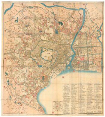
A Japanese woodblock wall map of Edo
£4,500TAKAI RANZAN.
Published In 1859
Stock No. 23071 -

An early example of this 17th century map of Lithuania
£1,200HONDIUS, Henricus.
Published In 1640
Stock No. 24390 -

Five scarce Italian playing cards depicting Sweden and the Baltic
£700Anonymous.
Published In 1790
Stock No. 24237 -

Decorative 18th century map of Norway
£460HOMANN, Johann Baptist.
Published In 1720
Stock No. 24171 -

Cape of Good Hope naval prospect
£400AA, Pieter van der.
Published In 1719
Stock No. 24077