- Reset all
- African Islands
- Antigua
- Asia Continent
- Black Sea
- Books about Maps
- Calabria
- Campania
- Central Asia
- China
- Europe
- France
- French Regions
- Hispaniola
- Hungary
- Iceland
- India
- Italy
- Leinster
- London Environs
- Maritime
- Monaco
- Near East
- North America
- Pacific and Australasia
- Pacific Islands
- Provence
- Rutland
- Scientific Instruments
- Somerset
- Southern Italy
- St Helena
- St Lucia
- Syria
- Tartary
- West Indies Maps
- Worcestershire
- World
- Zodiac
Showing 1–12 of 1406 results
-

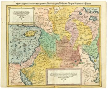
A geological map of the Duchy of Tyrol
£2,350STOTTER, Michael.
Published In 1851
Stock No. 23050 -

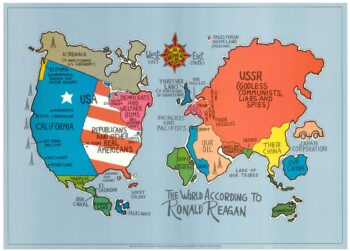
A serio-comic map satirising Ronald Reagan’s view of the World
£650HORSEY, David.
Published In 1984
Stock No. 24474 -
16th century map of the Eastern Mediterranean in rare early colour
£880MUNSTER, Sebastian.
Published In 1550
Stock No. 24441 -

A Victorian game map of the world.
£5,500JONES, Thomas Henry.
Published In 1845
Stock No. 24423 -

Ruysch’s 1507 world map, with the earliest obtainable depiction of the Americas
£260,000RUYSCH, Johann.
Published In 1507
Stock No. 22807 -

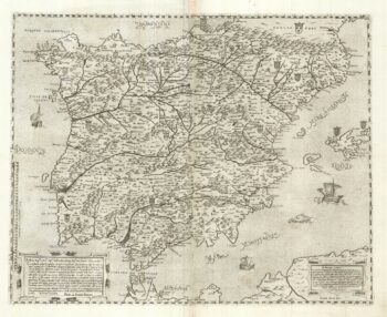
A two-sheet ‘Lafreri-School’ important map of Iberia
£9,750FORLANI, Paolo.
Published In 1567
Stock No. 24477 -

A 17th century chart of the eastern Mediterranean in fine colour.
£1,600DE WIT, Frederick.
Published In 1745
Stock No. 24490 -

de Hooghe’s spectacular chart of the Mediterranean Sea
£36,500HOOGHE, Romeyn de.
Published In 1694
Stock No. 24488 -

A view of the Battle of Lepanto engraved in 1572
£2,500CAVALIERI, Giovanni Battista de'.
Published In 1647
Stock No. 24486 -

A political map of the Partition of British India
£1,800BUREAU OF CURRENT AFFAIRS.
Published In 1949
Stock No. 24485 -
Uncommon 16th century Italian map of Cyprus
£1,600ROSACCIO, Giuseppe.
Published In 1598
Stock No. 24538 -

A rare lifetime printing of Blaeu’s view of Vesuvius erupting in 1631
£1,400BLAEU, Johannes.
Published In 1663
Stock No. 24506