Showing 1–12 of 103 results
-

Vrients’s scarce map of England, Wales & Ireland
£4,250VRIENTS, Jan Baptist.
Published In 1612
Stock No. 20271 -

A view of the Battle of Lepanto engraved in 1572
£2,500CAVALIERI, Giovanni Battista de'.
Published In 1647
Stock No. 24486 -

An instructional card explaining shipboard directions
£220Anonymous.
Published In 1840
Stock No. 24472 -

A scarce two-sheet map of England and Wales with side panels
£3,000WILLDEY, George.
Published In 1715
Stock No. 24165 -

A map of Philadelphia as the capital of the Revolution
£3,400LOTTER, Matthaus Albrecht.
Published In 1777
Stock No. 24398 -

A large scale map of Westmorland in fine colour
£1,500GREENWOOD, C. & J.
Published In 1824
Stock No. 24069 -
An important 16th century plan of Angra
£2,800LINSCHOTEN, Jan Huygen van.
Published In 1595
Stock No. 23737 -

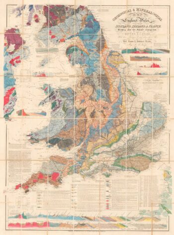
A detailed geological map of England and Wales
£1,500KNIPE, James Alexander.
Published In 1870
Stock No. 23418 -

A decorative marine print of early 18th century warships
£1,250HOMANN, Johann Baptist.
Published In 1730
Stock No. 24163 -

An 18th century maritime explanatory print
£1,200CHATELAIN, Henri Abraham.
Published In 1720
Stock No. 24154 -

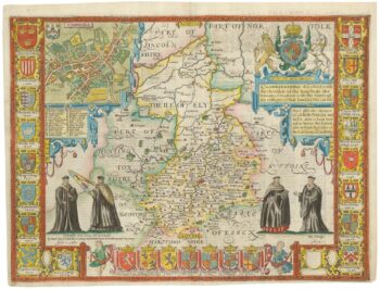
A rare issue of Speed’s map of Cambridgeshire
£2,200SPEED, John.
Published In 1665
Stock No. 24020 -

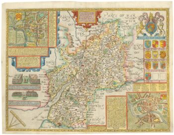
A scarce edition of Speed’s map of Gloucestershire
£1,800SPEED, John.
Published In 1665
Stock No. 24018