Showing 1–12 of 27 results
-

An 18th century map of the Americas
£550EULER, Leonhard.
Published In 1753
Stock No. 24536 -

One of the earliest maps to depict America
£42,500WALDSEEMULLER, Martin.
Published In 1513
Stock No. 24130 -

The first atlas issue of this 17th century map of America
£2,200HONDIUS, Jodocus II.
Published In 1636
Stock No. 19628 -

Speed’s landmark map of America
£3,950SPEED, John.
Published In 1665
Stock No. 23980 -
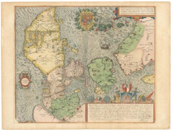
A superb 16th century map of Denmark
£2,000JORDAN, Mark.
Published In 1588
Stock No. 23838 -

A superbly decorated map of the Americas
£6,500HONDIUS, Jodocus.
Published In 1628
Stock No. 23601 -

A separately-issued map of Denmark, the earliest dated map by de Wit
£750DE WIT, Frederick.
Published In 1659
Stock No. 23255 -

The scarce second Galle plate for America used in the ‘Epitome’
£470ORTELIUS, Abraham.
Published In 1598
Stock No. 23190 -

17th century map of Dorset
£600BLAEU, Johannes.
Published In 1662
Stock No. 22703 -
The Fries edition of Wäldseemüller’s map of the Americas
£8,500WALDSEEMULLER, Martin.
Published In 1541
Stock No. 23045 -

An early 19th century map of Denmark in fine colour
£160LAURIE & WHITTLE.
Published In 1801
Stock No. 22819 -

The first map of the continent of America
£6,250MUNSTER, Sebastian.
Published In 1572
Stock No. 22614