Showing 1–12 of 31 results
-

A 16th century town plan of Tangier
£220VALEGIO, Francesco.
Published In 1598
Stock No. 24217 -

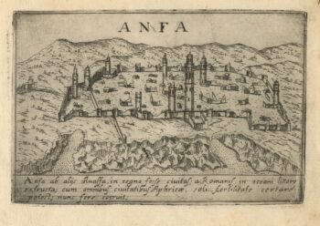
A 16th century town plan of Casablanca
£240VALEGIO, Francesco.
Published In 1598
Stock No. 24215 -

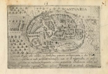
A 16th century Italian plan of Canterbury
£280VALEGIO, Francesco.
Published In 1598
Stock No. 24131 -

An 18th century map of the Americas
£550EULER, Leonhard.
Published In 1753
Stock No. 24536 -
A caricature of Churchill as an octopus, produced for occupied France
£1,000S.P.K.
Published In 1942
Stock No. 24106 -
One of the earliest maps to depict America
£42,500WALDSEEMULLER, Martin.
Published In 1513
Stock No. 24130 -
The first atlas issue of this 17th century map of America
£2,200HONDIUS, Jodocus II.
Published In 1636
Stock No. 19628 -
Speed’s landmark map of America
£3,950SPEED, John.
Published In 1665
Stock No. 23980 -
A 16th century map of Morocco
£700ORTELIUS, Abraham.
Published In 1601
Stock No. 23718 -
A superbly decorated map of the Americas
£6,500HONDIUS, Jodocus.
Published In 1628
Stock No. 23601 -
The story of the Spanish Armada from the House of Lords tapestries
£950PINE, John.
Published In 1739
Stock No. 23245 -
The scarce second Galle plate for America used in the ‘Epitome’
£470ORTELIUS, Abraham.
Published In 1598
Stock No. 23190